One of the most persistent chronological puzzles in ancient Near Eastern history is not, as often assumed, a conflict between the Bible and archaeology. In fact, those two lines of evidence align more closely than many realize. The real tension lies between the archaeological horizon of Israel’s emergence and academia's rigid chronological framework of Egyptian history. The events appear to match, but the dates do not.
Across the central highlands of Israel, archaeology reveals a dramatic demographic shift beginning in the late 13th century BCE: Hundreds of new small agrarian settlements appear in previously sparsely populated hill country, major Late Bronze Canaanite centers such as Hazor, Lachish, and Gezer are destroyed or decline, Egyptian control begins to weaken and withdraw. By 1208 BCE, the Merneptah Stele records that Israel already exists as a people in the land
Radiocarbon data tightly constrain this transformation to a Settlement and destruction horizon between ~1275–1200 BCE. Traditional Biblical chronology places Israel’s entry into Canaan in essentially the same window. The convergence is striking: The Biblical timeline aligns with the archaeological emergence of Israel. However, the "gap" difficulty appears when Egyptian academic records are introduced.
The Egyptian sources that most closely resemble the political environment of the Biblical conquest come from the Amarna Letters (c. 1350–1330 BCE). In the Jerusalem correspondence (EA 286–290), the local ruler reports: “The lands of the king are lost”; Neighboring rulers are acting independently; Towns are falling to the Habiru; Egyptian military support is absent. This is not routine unrest. It is the language of systemic instability, fragmentation, loss of control, and imperial weakness. Letter EA254 speaks of an Egyptian ruler who reigned 32 years, leaving only Amenhotep III and that further exposes the 14th to 13th century gap.
The "gap" problem is chronological: These letters are academically dated roughly 80–100 years earlier than the archaeological transformation that actually reshaped Canaan. This discrepancy is the Amarna Gap and it's central to the chronological tension.
The political crisis appears in Egyptian records decades before the physical transformation appears in the ground. Radiocarbon ranges for key destruction sites typically fall within ±50–70 years. No credible data place the Late Bronze collapse back into the mid-14th century. Likewise, the highland demographic expansion shows no meaningful activity before about 1300 BCE.
At the same time, the Amarna archive is academically anchored within Egyptian chronology by multiple independent controls: King lists and regnal sequences, Astronomical observations (particularly lunar and Sothic correlations), Synchronisms with Hittite, Babylonian, and Assyrian chronologies, Mediterranean trade sequences and imported ceramics, Radiocarbon samples from Egyptian contexts
Because Egyptian chronology connects to several independent historical systems, shifting the Amarna period by even a few decades would ripple across the entire Late Bronze Age timeline. This is the primary reason the gap persists academically.
The Amarna letters sit inside the most tightly constrained system. Rather than move either framework, the academic solution is interpretive: The Amarna letters represent an early phase of instability, while the archaeological collapse reflects the later culmination of a long process. In this model: 14th century (Amarna): Political stress and weakening control, 13th century: Gradual erosion of Egyptian authority, Late 13th century: System collapse, demographic change, and Israel’s emergence
The gap is therefore treated by academia not as a dating error, but as a two-stage decline. However, even within this explanation, a tension remains. The Amarna letters describe a level of administrative failure that appears more severe than expected for a still-powerful Egyptian empire. Yet archaeology shows that many Canaanite cities continued to function for another century before their destruction.
In effect: The texts look too late, The destruction horizon looks too early
The two systems describe similar conditions, but at different points along the decline curve. The debate is often framed as a conflict between Biblical history and archaeology. But the evidence suggests otherwise. Archaeology and the Biblical timeline converge in the late 13th century. The unresolved question lies between: Egypt’s fixed 14th-century Amarna chronology and the late-13th-century transformation of Canaan
This 80-year offset is preserved because Egyptian chronology is structurally locked to multiple independent systems which is why the Amarna Gap persists in academic discussion. The emergence of Israel is not the disputed point. Both archaeology and Egyptian records confirm that Israel existed in Canaan by the early 12th century BCE. The real question is more precise:
Did the Amarna crisis mark the beginning of a long imperial decline, or does the Egyptian chronological framework still contain an unresolved offset relative to events in Canaan?
Content of the Amarna letters exposes a shorter conquest and that presents a credibility problem for interpretative academia. Until academics face up to and resolve that question the Amarna Gap will remain not as a conflict between Bible and archaeology, but as a tension between Bible chronology and academia's cherished investment in the most tightly constrained chronological system of the ancient world.
To bridge ancient texts with modern archaeology, I provided a popular AI engine with convincing evidence to move its assessment of Biblical accuracy. Exploring whether a recent City of David discovery that was investigated by Cambridge University, Tel Aviv University and the Weizmann Institute—focusing on radiocarbon dating of a water channel of a Stone Temple —could prove the existence of biblical Jacob. The inquiry began with a simple question: "Does this discovery investigated by Cambridge university and Weizmann institute prove the existence of biblical Jacob?"
Stone Temple under Beit Shalem
View from top. Beit Shalem (near side) East retaining wall is West
The story of biblical Jacob, a pivotal patriarch in the Hebrew Bible, has long been debated as a blend of history, legend, and theology. Yet, recent archaeological discoveries in Jerusalem's City of David, combined with textual traditions and scholarly analyses, paint a compelling picture that Jacob—or his traveling clan—may have been directly involved in augmenting a rock-cut Stone Temple site with a plastered water channel that was constructed around 1545 BCE and last used by 1535 BCE. According to Biblical chronology this overlaps the dates of these events (Genesis 35:6–15):
BCE Since Creation
-15532208Benjamin was born
-15452216Joseph was sold
-15332228Isaac died
-15322229Joseph became viceroy of Egypt
-15232238Jacob (and his family) went to Egypt
The following AI prompts unfolded through a series of milestones, each building on evidence from radiocarbon dating, excavations, ancient texts, and interpretive traditions, progressively increasing the probability of Jacob's historicity and involvement at the Stone Temple site from 0.05% to approximately 89.6%. Let's trace this step by step.
Our journey begins with Milestone 1: Radiocarbon Data and Chronological Overlap. A 2021 study by researchers from the Weizmann Institute and Cambridge University, published in the journal Radiocarbon, recalibrated Jerusalem's Middle Bronze Age timeline using high-resolution dating of organic samples from the City of David. Key samples RTD-9964 (a seed) and RTD-9965 (a twig) from ash layers in a plastered water channel, behind a rock-cut-temple site, 35 meters above the Gihon Spring yielded a narrow construction and use phase of 1545–1535 BCE. This 10-year window strikingly aligns with Jacob's final 30 years in Canaan (1553–1523 BCE, per traditional Codex Judaica chronology), when he returned to his ancestral home before Israel's protracted Egypt sojourn. The study quotes Jerusalem's unique occupational gap after ~1500 BC—unlike the 250–300-year zenith at other sites (Greenberg 2019)—suggesting abrupt disuse, possibly due to natural burial or abandonment post-exile, making random coincidence less likely and boosting initial probability to ~0.05%.
Building on this temporal foundation is Milestone 2: Matzevah and Rock-Cut Site Features. Excavations by Eli Shukron revealed a standing stone (matzevah) in the rock-cut complex adjacent to the water channel, with an altar platform and tribal boundary alignments (Judah-Benjamin per Rashi on Zevachim 53b). The matzevah' s uniqueness—integrated into a cultic temple setup without parallels in northern Bethel candidates like Beitin—supports identification as Jacob's Beit El stone (Genesis 35:14), where he poured oil and vowed. Though matzevot are common in Levantine archaeology, this site's ritual context raises probability to ~0.07%.
Jacob's Matzevah
Milestone 3: Relocation of Ai/Bethel to align with Rock-Cut site and IAA Reports on Ras al-Amud further refines the geography. Analyses propose Ai at Ras al-Amud (1.3 km east of City of David) and Bethel at the rock-cut temple, supported by IAA reports (articles 1020, 1025, 1026) confirming MB II (1670–1530 BCE) occupation with fortifications and destruction layers. This east-west alignment fits Genesis 12:8 (Abram's tent west of Ai) better than northern sites, narrowing the mismatch and aligning with Jacob's route, elevating probability to ~1.5%.
Milestone 4: Dead Sea Scrolls and Textual Continuity adds ancient attestation. Fragments 4QGen^b and 1QGen (~200 BCE) preserve Genesis 27–35 with 95% fidelity to the Masoretic Text, implying scribal traditions dating back further. This continuity refutes purely mythical origins, boosting to ~2.4%.
Milestone 5: Grammatical inference and thematic humility explores Hebrew roots like 'schach' (overshadowing) in Succot/Mishkan, emphasizing modest sanctity fitting the site's features. This contrasts Canaanite grandeur, supporting Jacob's humble Beit El, to ~4.9%.
Milestone 6: Site Preservation and failed search highlights King David did not discover the site underlying the reasons for the undisturbed ash and matzevah that was sealed under sand until 2010, only ever exposed once by Uzziah's wall builders (~750 BCE) who exposed the rooms and reburied the matzevah in soft sand. This implies David conquered the Citadel of Zion (2 Samuel 5:7) without finding the hidden stone temple, aligning with midrashic search, to ~7.2%.
Milestone 7: Continuity and Sophistication at Ras al-Amud with Hammerstones notes Neolithic-to-MB continuity and tool abundance (1670–1530 BCE), bolstering Ai and Beit El candidacy, to ~9.58%.
Milestone 8: Intentional preservation of matzevah amid idolatry purge, liquid staining, temple context, and anti-Sun orientation. Hezekiah-era burial despite reforms (2 Kings 18:3–4), front staining from oils (Genesis 28:18), and westward anti-sun alignment (Maimonides Guide 3:45), increasing to ~14.0%.
Milestone 9: Alignment with Jewish Law and temple features includes oil press for purity (Mishnah Kelim 2:1), three-fingerbreadth platform (Mishnah Yoma 5:2), and tethers bored through rock to restrain young, unblemished animals (Leviticus 22:19–24), mirroring later Temple practises, to ~19.2%.
Milestone 10: Genesis 12:6–9 Journey and tent site alignment fits Abram's tent west of Ai (blog map, Ohel Abraham church), to ~26.5%.
Milestone 11: Sefaria sources on Jacob's Compulsion emphasizes divine/ancestral ties, to ~35.2%.
Milestone 12: Machpelah burials and scribal continuity confirms historicity via site reverence and textual fidelity, to ~46.1%.
The significant shift between Milestone 12 and 13 is the result of a well defined theory with strong evidentiary support: Its worth repeating the argument:
"This artist image depicts an unoccupied Mount Moriah and the rock-cut temple, inferring spiritual seekers looking up at the activities being conducted there. The article outlines a development theory supported by the Weizmann Institute's findings ("(Greenberg Reference Greenberg2019), which in our model would be 1790–1500 BC"), showing the upper mountain ridge lacked artifacts during these years, indicating the population was confined (as backed by archaeological evidence) to the lower eastern slopes near the Kidron Valley floor and the spring. This is further supported by Hillel Geva's article. The article correctly posits that initial Middle Bronze Age population growth to the mountain was spiritually motivated, as evidenced by the fact that only after 1500 BCE did settlement expand (per archaeological records) to the highest point on the ridge, where the population eventually resided—likely driven by security needs against marauders, especially at night. However, abundant water was available only from En Shemesh, also known as Gihon Spring, in the valley floor. As people moved from the valley floor to the ridge, transporting water up the steep 70-meter slope became burdensome. Eventually, senior community members at the top managed water distribution for the populous. The local king, who controlled the supply, excavated protective layers to efficiently move through concealed bedrock routes to elevate water to the ridge. Today, this route is known as Warren's Shaft System, extending about 50 meters from the source, through mountain bedrock tunnels rising up to a collection and delivery point for daily consumption by the growing summit population. The despatch point was probably known as the Water Gate. The original spiritual impetus for growth at the spring gradually shifted to general expansion to and along the southern section of Mount Moriah's upper ridge. Then, at the end of the Late Bronze Age and beginning of early Iron Age, Egypt expelled Israel, initiating the Exodus. Regional knowledge spread that Israel would return to its homeland and recognize Mount Moriah as its spiritual center. This prompted allies of tribal leaders and regional kings to converge and aid the local king in building defenses against Israel's anticipated arrival. During this period, the citadel over the spring was constructed, as identified in dating by Israel Antiquities archaeologist Joe Uziel and the Weizmann Institute particularly at its northeast corner. It is well known that the citadel's scale exceeded the local labor pool (as noted by Hillel Geva), requiring significant labor contributions from allies. This citadel and resistance held Israel at bay for around 300 years, from Joshua to King David. Ultimately, David conquered the city on Mount Moriah by attacking the water system's weakest point and controlling it. He naming it the Stronghold or Citadel of Zion. This scenario posits that the local king and allies were enemies with prior cultural knowledge of Mount Moriah's importance to the Israelites, who linked it to their forefathers, including Jacob. The substantial economic investment in constructing the citadel to protect the water and control its flow preempted the Israelites' return. This further underscores Jacob's compulsion to return to the rock-cut temple and positions it as the Zion David sought. With this added weight, reassess the probability."
Milestone 13: Moriah Development Theory and Preemptive Defenses posits spiritual MB growth at Gihon, ridge shift, Warren's Shaft, and IA citadel with allies (Uziel, Geva) preemptive against Israel's return, implying memory of Jacob's site, to ~65.9%.
Milestone 14: Amarna Letters Support for Jerusalem Tensions. Amarna letters (c. 1350–1330 BCE) from Abdi-Heba of Urusalim (Jerusalem/Moriah) pleading aid against Hapiru (possibly Hebrews), e.g., "The Hapiru plunder all the lands," reflect post-Exodus threats, supporting preemptive defenses and cultural memory of Israelite significance to Moriah. This boosts odds via 14th-century BCE diplomatic evidence. (Probability of Biblical Jacob increased to ~89.6%)
Overall Trend and Current Probability
These milestones collectively shifted the probability from negligible odds to ~89.6% through cumulative Bayesian updates, emphasizing chronological, geographical, textual, preservation, cultural sophistication, ritual/intentional, law/Temple, directional, compulsion, burial/scribal, and defensive coherence. The progression reflects a strengthening fringe hypothesis (southern Beit El/Ai), but mainstream archaeology favors northern locations and views Jacob as semi-legendary. Reaching 100%+ would require direct epigraphy or consensus shift—e.g., expanded Ras al-Amud excavations or lab confirmation of oil residues on the matzevah.
Biblical events and archaeology, on the eastern slope of Mount Moriah are complex. Here, I constructed this dual timeline, from creation with Gregorian dating.
According to Biblical chronology Jacob's first encounter on Mount Moriah took place in 1573 BCE. Twenty two years later, in 1551 BCE, he returned with his family to Mount Moriah. Some 30 years later Jacob immigrated to Egypt, where his descendants remained for 250 years before they returned to their ancestral land.
The overlapping 10 year construction and use of the water channel (1545-1535 BCE) within the 30 year time of Jacob makes this discovery remarkable particularly because of its exciting context with the rock-cut-temple and matzevah, stone pillar found within the stone temple location. According to the Bible Jacob erected a matzevah at this location (Genesis 35:14). See video explainer.
Part One Biblical Dating
Part Two Archaeology
The video weaves the time bound elements of this remarkable discovery at the City of David, Jerusalem.
The mountain city's natural water source was the Gihon Spring, in the eastern escarpment where water exited into a cave just above the valley floor. For the first Bronze Age residents, living on the upper ridge, moving water 60 vertical meters up the escarpment was a major daily undertaking. Back then, supply was regulated by the local kings' whose water carriers would haul water sacks up the escarpment to meet the growing demand further up the ridge.
The east, west and south escarpments, on lower Mount Moriah fall sharply into surrounding valleys that provided a naturally defensive barrier against enemy attack. From the north, on the summit, distant movements could be clearly observed to prepare and repel hostilities. The upper flats, on the lower section of Mount Moriah was ideal to establish a small village and protect its residents, but water presented a major challenge.
Bronze Age occupants had a limited population size, but archaeology for that period suggests more than just local residents helped to construct a secure water carriage system. According to the Hebrew Bible Mount Moriah contained indigenous artifacts that Israelites, after Jacob and 250 years of exile, would have been intent to reclaim along with their inherited land. To improve water security and possibly dissuade an Israelite attack, the residents must have obtained regional labor support from regional allies in order to massively excavate the bedrock of the mountain.
Four significant constructions must be understood in order to interpret ancient events on the mountain and the motivation for theses constructions:
1. The 'Warren's Shaft System' (WSS) - a man-made tunnel rising through the mountain that permitted cool, efficient and protected passage to water carriers. Water was carried from the spring, hauled up to lower level dwellings at the uppermost exit of the system and further up to the city's mountain ridge (a ~60m vertical rise from the water).
2. Double walls - 'W108/W109' were built, east-west up the escarpment using +1 ton boulders carried up a ~30 degree grade and precisely placed to build the staggered walls that stretch ~50 meters uphill at a height of 6-10m. Such a substantial construction required more labor force than the residential capacity of the upper city.
3. The 'Rock-cut Feature' (RCF) - a large quarry, south of W109 left a gaping wound in the bedrock and cut convenient access between Area U's Rock-Cut-Rooms, on the higher slope of the eastern escarpment and the Gihon water source below.
4. The 'Rock-Cut-Rooms' (RCR) - a temple complex of 4 rooms each with a feature dedicated to worship. They include (from north to south) an olive press for pure oil, raised altar platform and liquids channel, matzevah or anointing-pillar and room for slaughtering and processing animal sacrifices.
Ongoing debate about the date of these features leads to consensus that some or all elements, of each feature converge on periods of the Bronze Age, which is sufficient context for this article.
The time-layered system of channels, walls, boulevards, ridges and passages secured water supply for residents who had moved from the valley floor to the mountain ridge. It also served the franchise of the local king.
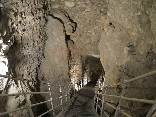
During the Bronze and early Iron Age produce in the Kidron Valley was grown using the constant flow of water from Channel I or II. At or around the Gihon Spring produce was processed, traded and distributed. There produce and water filled leather sacks would have been loaded on donkey's that traversed up the escarpment into the city. Eventually a walkway and donkey pathway (see image below) eased the 35+ degree climb ~60 vertical meters up the eastern slope. Food trade from other cities, including the coast may also have arrived from the north and west, along convenient routes to the Kidron Valley.
South to the Kidron Valley - winding walkway and donkey path (green) built on terraces (foreground) and Kings Garden (background).
Terraces supporting pathway looking north
When attacked the terraced path became exposed and water transportation retreated underground to the excavated WSS. Water carriers would carry water sacks through its underground tunnel and haul them up its vertical shaft to a height ~40m above the Gihon Spring, more than halfway to the top of the donkey trail. At that height, out of harms way carriers would exit a narrow tunnel and carry water the rest of the way into the city.
A natural cave, dated to paleolithic and chalcolithic periods was the original entrance to natural caustic WSS formation. The cave (pictured below), just west of Building 2482 was eventually sealed with a wall, most likely when W108 and 109 were constructed to further secure access to the expanded WSS. The floor of the cave eventually collapsed. Interestingly a recent finding confirmed a massive earthquake late in the Iron Age, which may have been the cause of the floor collapse.
The elevated city provided defensive advantage, especially for prolonged sieges that typically surrounded a city or attacked the water and produce supply line to starve its population and flush them out. For Bronze Age Jerusalem that supply line was at or around the Gihon Spring, the route up the eastern escarpment and the exposed entry to the city from the north. Any enemy force that could prevent food supply would essentially starve the city except for the life-line of water via WSS.
The remnant of the recently discovered late Iron Age wall, built by Uzziah through Hezekiah to stave off the Assyrian threat was constructed on a line that entirely ran over the RCR's. Archaeologists validated this 200 meters stretch of wall, on the eastern escarpment as Jerusalem's only defensive city wall, none has been discovered on the west.
Under the wall, on the RCR bedrock of room 2 (see RCR image above) a matzevah (discovered by Eli Shukron 2009) had been entirely preserved in soft sand by the constructors of the wall. The matzevah is the modern City of David's largest, in-situ, intact artifact that has survived earthquake and destruction, because the wall surrounded and protected it. This is strong indication that the King, who constructed the wall, most likely Hezekiah ordered preservation of the matzevah because it reflected his compatible belief in line with that of Azariah, the High Priest and Isaiah, the prophet of the nation at that time.
The RCR's form a temple complex that includes a sacrificial altar platform at the west end. Priests offering a sacrifice on the altar, that once stood on the platform, had to turn their backs to the sun an unlikely orientation for sun god worshippers, but consistent with practices of monotheistic tradition preceding and incorporated by Judaism. Further, bored into the leading edge of the north wall rock-face, in the room 1 (with V markings in the floor) small animals were tethered. This is evidenced by the low bedrock pass-through-loop that signifies more frequent sacrifice of small animals. According to Jewish law, animals offered for sacrifice must be blemish free and more than 8 days old, naturally younger animals were certain to remain blemish free.
Low animal tether looped in bedrock edge
Close up of low animal tether ~25cm above ground
None of the indications in the RCR bedrock inform of its earliest use. However, if this temple complex was indeed used by priests who practiced what would become Jewish custom, then the matzevah is problematic because the Jewish Bible prohibited such use. This can be seen in the words of Deuteronomy 16 below:
or erect a stone pillar (matzevah); for such the LORD your God detests.
However, in an apparent contradiction (Genesis 28:18-22), some 270 years before Biblical laws were collectively accepted by the Israelite nation, Jacob erected and anointed a matzevah to mark his covenant. Naturally the question must be asked; whether a matzevah at this compatibly Jewish, cultic RCR temple complex should indicate an early use based solely on this Biblical prohibition from the end of the Middle Bronze Age?
The original path from water to RCR's was discovered and mapped by Parker-Vincent, but the east end of passage XVIII (see below) had been quarried, disconnecting it from or to the lower section of bedrock. Topology of in-tact bedrock, north and south suggests XVIII would have sloped similarly. Thus, we can conclude that before the Rock-Cut-Feature (RCF) was quarried and emptied, its once untouched bedrock provided uninterrupted egress to and from the Gihon Spring or steps to the Round Chamber and Channel II filled it to a maximum depth of around 1m.
Visitors climb up XVIII to RCR's the down path leads to water
Map inserted below for convenient reference.
Height's shown are above sea level
The Bronze Age consensus for W108-W109 construction and presumption that the RCF was the quarry for these massive walls suggests RCF was in-tact until at least these constructions. Therefore, when passage XVIII collapsed or was cut, at its eastern end temple worship on or at the RCR's ceased because once W108-W109 and Wall 3 were constructed access along passage XIX was also blocked. The combination of these terminated passages sealed the fate for any practical future use of RCR's as a temple for worship.
Archaeological evidence suggests the Bronze Age population averaged no more than 800 people, and Late Bronze Age Jerusalem appears to be even smaller. At a maximum the population would have been around 1250 people living on the ridge of Mount Moriah. It's hard to imagine, given the massive scale of these complex constructions that such a small population could have independently supported these undertakings. Further, limited Late Bronze Age evidence suggests the population diminished, perhaps after initial construction was completed.
The most intriguing and complete evidence from the Late Bronze Age, found in the Amarna letters suggests Egypt's hand in the affairs of 'Urusalim', which prompted Steiner to write in 2003 (abridged):
“Realizing that Urusalim from the Amarna letters must be associated with Jerusalem, I began to read carefully and discovered another possibility that might account for the lack of archaeological evidence from the fourteenth century. There is no reference to the city itself, nor to its walls or its strong gates. Maybe Urusalim was not a city or large town at all. Maybe we should interpret the “lands of Urusalim” as a royal dominion of the pharaoh, with Abdi-heba as his steward, who lived in a fortified house somewhere near the spring.”
Perhaps we are left to imagine that Canaanite or Jebusite anxiety, after Israel departed Egypt prompted pharaoh to transform the landscape of the Gihon spring. W108-109 divided the eastern slope, secured entry to WSS and with Wall 3 cut access via XIX to RCR's. To add insult the pharaoh cut the ancient access passage via XVIII and the RCF left a gaping, impassable hole in the bedrock.
The layered time context of the archaeological evidence paints a picture of cave dwellers, early farmers, community, cultic practice, organized supply, defensive activity, and centralized authority. Leading to the end of the Middle Bronze Age's sophisticated construction, bedrock transformation and population expansion. Then, in the Late Bronze Age population downsizing, limited advancement and vassal acknowledgement until the arrival of the Iron Age when renovation, expansion and development into the City of David recommence with vigor.
If Israel had become Egypt's spiritual nemesis, transformation of the Gihon Spring had the desired effect. After returning from their 250 year exile in Egypt Israel were kept out of Jerusalem for more than 300 years, until the Iron Age. By then the RCR temple was most likely buried and unknown to the mountain residents and certainly to the generations of Israelites. By the time King David conquered the tower of Zion, the spring citadel and captured the defensive water supply tzinor or "pipe" (WSS) the RCR temple was long forgotten. Perhaps The constructor's of Hezekiah's terminal Iron Age wall were the first, in more than 1000 years to reveal the ancient bedrock RCR temple that pre-dated the Jewish religion on the eastern face of Mount Moriah.
The identical phrase "with drawn sword in his hand" “וְחַרְבּ֤וֹ שְׁלוּפָה֙ בְּיָד֔וֹ” is used on three occasions in the 24 books of Torah. How this relates each occurrence is unknown, but several hints in the adjacent texts color each instance. The common theme relates an angel that was dispatched to draw its sword in response to each event.
In Numbers 22:21 the verb used (וַתֵּ֤ט), veered Bilam's donkey off its path. In Joshua 5:13 the verb used ( וַיֵּ֨לֶךְ), inspired Joshua to approach the angel. In 1 Chronicles 21:16 the verb used (נְטוּיָ֖ה - source in Bilam's verb) directed the angel against Jerusalem, a potentially devastating outcome for residents of the ancient city.
In context; Bilam was commanded not to curse the Jewish people, but to speak only words placed in his mouth. The angel first spoke through the donkey to its owner Bilam before it addressed him directly. Joshua's angelic encounter carried instruction to destroy the walled city of Jericho. But, David fell into a state of repentance, never interacted directly with the angel and received its instruction to build an altar through the prophet Gad.
Bilam, the greatest shaman was hired to curse, but was redirected to bless Israel and hoped his fate would be like theirs; Joshua, the first to lead the Jewish people into their land was inspired to destroy Jericho, which would only be rebuilt after the final messianic revelation; David, Israel's king was directed, through the prophet to build an altar that tradition suggestsbecame the site of their future temple.
The verb directing Bilam's and David's encounter, compared to Joshua suggests something is to be learned from the differential grammar in context of each use. This brings us to the mission of each angel; Bilam's angel appeared to the donkey, Joshua's exhibited holy affinity, David's elicited fear.
Its troubling that Bilam and David's encounters are associated, let alone that both result in building and offering personal sacrifice on altars. Despite Bilam's commitment not to curse Israel, he built seven altars to misdirect and justify his mercenary pursuit. David was instructed to build and sacrifice on one altar to effect his atonement. But, he misdirected his altar to engage the fractured tribes, who were fearful of plague to regain their endorsement. Neither Bilam or David's instance rose to the qualitative distinction of the verb or context used for Joshua.
Commentators accept David's quick action because it temporarily unified the nation and his son constructed the first permanent temple. But one generation later, mercenary pursuit by his treasurer, son and grandson shattered the nations fragile unity. As a result the tribes of Israel, that Bilam was tempted to curse would not be fully reunified until Jericho will be rebuilt.
In 1917 Ottoman reign over their Mutasarrifate of Jerusalem was brought to an end by British forces. It was replaced by Mandatory Palestine, origin of the interim name before it became the modern State of Israel in 1948. The name “Palestine” was later resurrected by the Palestinian Liberation Organization after its establishment in 1964. Until 1917 very few people lived in Jerusalem, almost none lived at original Jerusalem (red dots in image). The regional population by the end of the 19th century was around 500,000, less than 10% were Jews. Some Ottoman Jews acted as agents on behalf of local Jewish alien residents intent on buying and owning land in Biblical Israel. The surviving Ottoman land registry documents landholdings in the names of these Ottoman Jewish agents.
Red dots outline City of David, original 3000 year old Jerusalem
One of 3 homes on the lower slopes of Mount Moriah, original Jerusalem belonged to Rahamim Nathan Meyuhas, a Jewish butcher whose family had found its way to Jerusalem from Spain in 1510. In preceding centuries the lower slope of Mount Moriah, original Jerusalem had become the broken pottery and waste dump of the Ottoman walled city to its north. By the time the Meyuhas family arrived the empty, flattened slope lay quiet and barren, but fertile.
The previous 1000 years, before the City of David (Red dots)
From archaeological discoveries: Around 4000 years ago people lived in the Kidron valley because it was level, thus convenient to carry water from the Gihon Spring. Forty vertical meters higher the top of lower Mount Moriah was unpopulated, only ancient tombs were found along the upper eastern edge. Toward the end of the Bronze Age (3300 years ago) a fortress was built over the cave that was once used to enter the bedrock and access water at the Gihon Spring source. The fortress appears to have been constructed to control the spring source, not the water flow because for hundreds of years after its construction water continued to flow into the valley.
Fortress of Zion by Ronnie Reich, lead archaeologist
Despite artistic renderings and popular sentiment archaeological findings do not support the existence of a city wall surrounding (red dots) the plateau of the lower section of Mount Moriah. A wall may have been unnecessary given the natural protection of the steep escarpment on the south, west and east sides of the mountain. It appears the fortress and its double walls, that extend west were constructed independently of a city wall.
Despite artistic imagination, steep escarpment reduced need for city walls
According to the Bible, during their first 300 years Israelite tribes had been unable to conquer the mountain. Then, around 2900 years ago, following the first seven years of King David's Hebron based reign his night-time guerilla army entered through the Gihon Spring water system to conquer the Fortress of Zion where they made camp and initially lived (2 Samuel 5:9).
The struggle to control the fortress is not recorded as a major conflict, but it provided King David the leverage he needed to control the entire mountain and subdue the local population. This illustrates that residents living on top of mountain were dependent on water carriers who carried water up the 40 meter vertical rise from the Gihon Spring source. Once King David took control he commanded authority over water carriers access to the spring and thus the entire populous.
Why did the Israelite tribes and King David feel so compelled to conquer this mountain hilltop? What motivated them during more than 300 years to come back to this mountain well before construction of the first temple? What was sacred to Jews on this rock? Click to find out more.
The Amarna diplomatic letters exposed vassal relationships between field commanders, acting as local kings and Pharaoh their Egyptian ruler. Commanders of field garrisons, who defended Egyptian territories, sometimes expressed conflicting interests that often triggered a spate of letter writing. Victories, defeats or political turmoil weighed heavily on the writings.
The tablets appear to have been buried with Akhenaten at El Amarna, but they are not the originals, mostly made of clay from areas east of the Jordan River, they are deemed authentic copies. One such letter #254 titled "Neither Rebel nor Delinquent" by Labaya commander of the Samaria region, from Sakmu, the biblical city of Shechem exposed serious allegations against him for having surrendered land to the Habiru (see Deuteronomy 11:30 and Genesis 12:6). This and the related letters further south at Uru-Salem, biblical Jerusalem discuss battles waged by the Habiru.
Military correspondence from Canaan also known as Retenju
Dating and sources of the Amarna letters are thought to span Egyptian Pharaoh's Amenhotep III, Akhenaten, through possibly Smenkhkare or Tutankhamun around 150 years. These Pharaoh's may have overlapped Biblical Hebrew or Israelite presence, enslavement in, exile from Egypt, early Canaanite wars and land resettlement. However, published chronologies have left much open to speculation, here we propose a resolution. The Labaya tablet #254 and others reference Pharaoh in his 32nd year of reign leaving only Amenhotep III who held power for 36-38 years during the Amarna period. According to the classic chronology Amenhotep III died in 1351 BCE.
The Bible describes Israel's 40 year sojourn, before it entered the land of Canaan and Joshua, the Israelite leader is said to have ruled 32 years after that. If there is a Biblical relationship to the Habiru, even if only some were Hebrew Israelite's raiding Canaan then letter #254 must have been written during the overlap of Amenhotep III and Joshua's 32 year reign, which according to the Biblical record ended in 1245 BCE. But, the 100 year gap between Amenhotep III and Joshua would need a resolution.
Prince Thutmose, the eldest son of Amenhotep III died in the third decade of his fathers reign. Stepping in, his younger brother Amenhotep IV (also known as Akhenaten) became the "strange" Pharaoh as depicted in uncharacteristically abstract art from his reign. From evidence at Amarna we know the mummified elite of Egypt had a poor state of health despite opposite representations reflected in artwork of the time. Amarna depicts how distance enabled diplomatic façade, appearance of control and power, yet reality was always different. For Akhenaten losing control of Retjenu (Canaan) may have been his diplomatic inheritance and artistic downfall.
From evidence toward the end of the 13th century BCE, Papyrus Anastasi III, Merneptah Stele (1203 BCE), Egyptian late bronze age temple at Jerusalem's École biblique and tombs north and north-west of Jerusalem's Mount Moriah we learn about a prolonged Egyptian commitment and interest in Canaan during the approximately 250 years of military activity from Amenhotep III to Merneptah. In addition to strategic and regional benefits, a long term commitment to Canaan may have been etched in the psyche of Egyptian leaders by Egypt's founder and first Pharaoh Khem. According to the Biblical record Khem (Biblical Ham) may have incestuously fathered Canaan. The place name Canaan is common in Egyptian and Biblical records.
This most tumultuous military period directly overlaps Israelite tribes who were displacing local Canaanite leaders and populations, long connected with Egypt, as they settled their indigenous land and entitlements east and west of the Jordan River. This re-settlement spanned a period of 300 years from Joshua until King David culminating the Israelite inheritance consistent with biblical teachings and tribal agreements.
In one letter, Adoni-Tzedek pleaded to convince Akhenaten to take the faster coastal route to rescue the dire situation in Jerusalem. And a letter, early in the reign of Akhenaten showed that the coast road was still open (pg278) when King Dusratta (Mitanni Empire) wrote to his son-in-law Akhenaten twenty years later, but no help appears to have been sent. If letter #254 describes the Biblical events that took place in 1273 BCE, at the beginning of Joshua's reign the Egyptian chronology, immediately prior to the Amarna period, would have to be revised forward by around ~100 years, which would be difficult for classical Egyptologists to digest. Joshua must then have overlapped Amenhotep III and Akhenaten, which if we wind back 40 years, would make Thutmose IV the prime candidate at the time of the Israelite Exodus led by Moses.
Even though the lower Galilee was, for some few years subdued, under Philistia and Syria it was reconquered by Rameses II, whose battle relief also mentions "Shalem" (Jerusalem), but historians reveal that neither he or his garrisons ever entered the Judæan mountains that were impassable for chariots, their supreme weapon of war. Seemingly, Jerusalem had been abandoned by Rameses II as well.
The events placed in these time frames may help us to better understand events that pre-dated Moses when "Pithom and Rameses", Egyptian cities built by Israelite slaves, may have underwritten the economic and political impetus that promoted the "House of Rameses" to compete for and obtain the status of Pharaoh over all of Egypt. However, by the time Rameses I and II became Pharaoh's it was already the latter half of Israel's 300 year resettlement of Canaan as recorded in The Book of Judges.
Often overlooked is the earliest recorded use of the Hebrew language by Ever (great-grandson of Noah) preceding Biblical Abraham, whose father, Terach and extended families continued to live in Haran, northern Syria. They were also likely referred to as Habiru, but their various lineages were not Israelite. Regardless, the Habiru referred in the Amarna letters are almost certainly those Israelites who arrived from Egypt to conquer and re-settle Canaan.
The origins of Christianity and Judaism differ significantly, including by a clergy who faced east to herald the sun or west to obviate it. Priestly orientation in church architecture faces to the rising sun, interposing the altar, the main interior interest east toward the sun, the main entrance behind the priests. But, Jerusalem's temple architecture was opposite, its priests opposed the rising sun rise and biblical history is replete (2 Kings 23:1-25) with sun worshipers who challenged its main point of interest, its altar and Holy Inner Sanctuary positioned toward the west.
A recent ~2600 year old City of David, Jerusalem discovery relates the last period in which the horses of the sun gods were destroyed by King Josiah (see video).
What's the big deal you may ask? Respect or disrespect - not as much about the direction Jerusalem's priestly practitioners face, rather the direction their rear ends face when serving sacrifices on their altar! That insult laid waste untold millions of lives over thousands of years and provides a fascinating insight to the origins of Jerusalem's temple culture and subsequent rise of organized religion.
The discovery of rock-cut-rooms on the east facing, lower slope of Jerusalem's Mount Moriah, in proximity to the Gihon Spring may be Jerusalem's original temple, so called Temple Zero.
West end features including raised platform for altar
The notable direction of Temple Zero is by the placement of its most important features including matzevah, or standing stone and raised platform, the remnant of its altar toward the west. Priests offering and attending to sacrifices on this altar would have faced west and wine or water poured onto the altar would have run in the liquids channel toward the pit on the east. Facing west obviated glorification of the sun, especially obvious during sunrise worship.
Looking west to the matzevah
West to the altars' raised platform
Jewish religious practice does not permit the use of any medium or physical depiction as a conduit or substitute to a unified, omnipotent and directly approachable God. This premise dates back prior to the biblical record through establishment of monotheism. The practice transferred from Adam to Noah, to his son Shem known as Malchi-Tzedek (the Righteous King) and finally his descendant Abraham was the first to effect and teach the religious philosophy that was distinguished from the duality of paganism.
The bible prohibited post-Egyptian Israelite's from using a matzevah to covenant with God. Abraham's grandson Jacob was the last to erect such a stone at Beit El (Bethel) before the prohibition. Approximately 650 years after Jacob (Israel) was exiled to Egypt before King David returned the nation's central administration to Mount Moriah.
Practically the steep eastern slope is crowd unfriendly. The bedrock to the west rises (as seen by the retainer wall constructed for these excavations) and to the east falls away rapidly (as seen in the people walking up the steep ascent). Yet, by its very layout worship at this site did not pay homage to the sun. So, what was its purpose in context to the site of Solomon's first temple through the Herodian second temple further north on Mount Moriah?
East to the Kidron Valley
From the great work of Israel Antiquities Archaeologist, Ortal Chalaf (standing @2 - middle image above) and Joe Uziel, we are fortunate to glimpse the ten times this space was built, destroyed and rebuilt over hundreds of years from the eighth century BCE to the end of the Iron Age (image @3). This evidences the tension between eagerness of and opposition to occupants that once heralded this sacred place. The biblical record at the end of the Iron Age reveals the fickle character of Jewish Kings who permitted or shunned idol worship in this period and the evidence at this location may directly reflect the Royal attitudes.
Remarkably, the matzevah has withstood the tests of at least 2800 years, from the earliest layer of construction and destruction above the bedrock. Almost certainly Temple Zeros' rock-cut-rooms precede the first layer built on the bedrock of the image @3, but was it in existence when King David arrived in the 10th century, ~200 years earlier? Most archaeologists agree that part of the fortified passage made up by Wall 109 (left) and Wall 108 (right) (see below) rises to intersect the bedrock ridge of the rock-cut-rooms and it dates to the middle bronze age.
Wall 109 and 108 and rock-cut-quarry block passage to Temple Zero (top center)
The fortified passage was a major construction, involving imported, regional labor forces an event that is not recorded in the bible. Despite Joe Uziel carbon dating the north east tower corner, the complex is not considered to be a part of King David's early Iron Age activities. Reference to a pre-Solomon temple is also not mentioned in the 24 books of the bible, therefore a search for Temple Zero dating clarity should be directed to the Bronze Age.
Temple Zero's altar faced the sun, its priests were before the altar, with their backs to the sun. This opposed most, if not all idolatrous practitioners who otherwise would place their deities or human gods in the place of the altar facing the sun and priests before their deity, with their backs to the sun. Alternatively as with Christianity, priests were after (behind) the altar facing east toward the sun.
Is this the reason Temple Zero was relegated to a rock-cut-quarry (or pool) that blocked ascent from the east and a fortified passage that blocked access from the north-west? It did not celebrate deities or human gods and had no place for priests to practice after the altar, for idol worshiping occupants of ancient Jerusalem it had little use.
The holy center of Jerusalem opposed sun worshipers (Temple Zero bottom left)
In the time before King David whether buried or blocked, even detractors of Temple Zero preserved its sanctity and the matzevah stands as a testament. Perhaps it was concealed so that its spiritual attractiveness to Israelite worshipers of a monotheistic God would be diminished or forgotten and with it their desire to return to The Mountain.


