A recent ~2600 year old City of David, Jerusalem discovery relates the last period in which the horses of the sun gods were destroyed by King Josiah (see video).
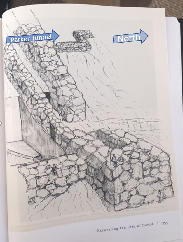
The notable direction of Temple Zero is by the placement of its most important features including matzevah, or standing stone and raised platform, the remnant of its altar toward the west. Priests offering and attending to sacrifices on this altar would have faced west and wine or water poured onto the altar would have run in the liquids channel toward the pit on the east. Facing west obviated glorification of the sun, especially obvious during sunrise worship.


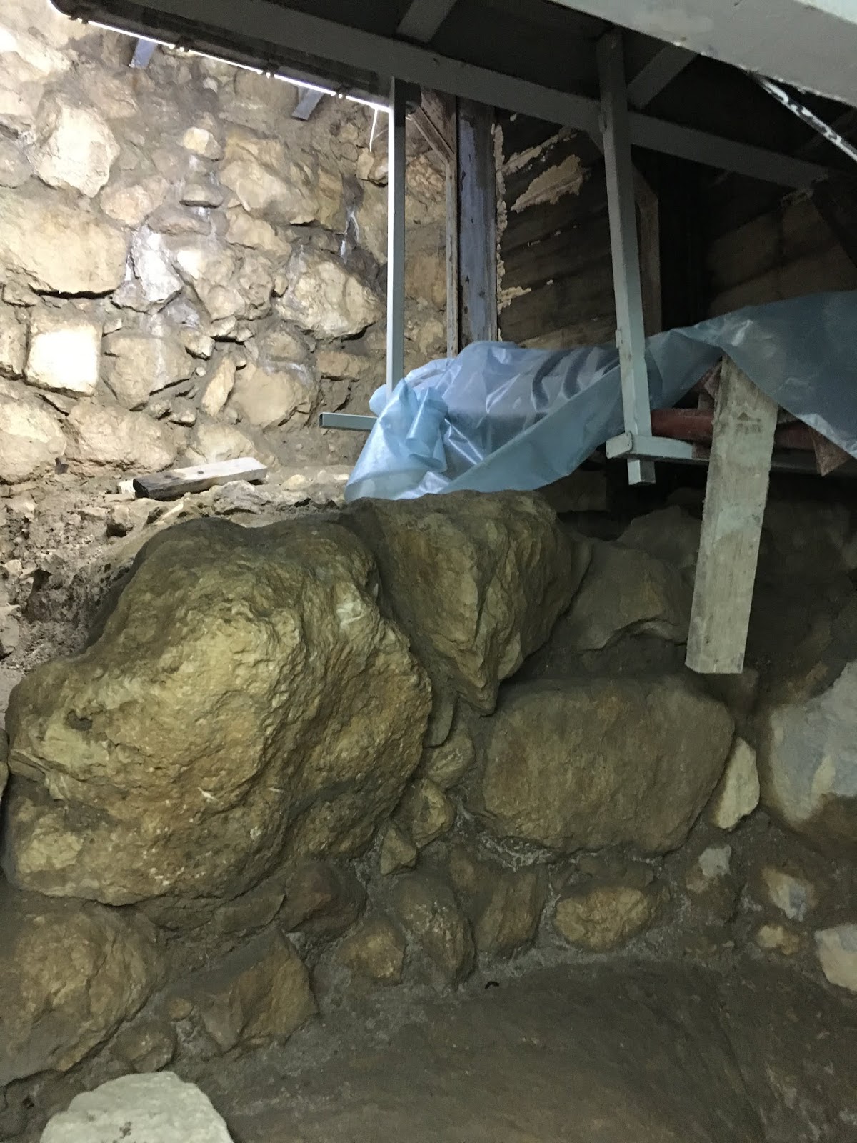
From the great work of Israel Antiquities Archaeologist, Ortal Chalaf (standing @2 - middle image above) and Joe Uziel, we are fortunate to glimpse the ten times this space was built, destroyed and rebuilt over hundreds of years from the eighth century BCE to the end of the Iron Age (image @3). This evidences the tension between eagerness of and opposition to occupants that once heralded this sacred place. The biblical record at the end of the Iron Age reveals the fickle character of Jewish Kings who permitted or shunned idol worship in this period and the evidence at this location may directly reflect the Royal attitudes.
Whats the big deal you may ask? Respect or disrespect - not as much about the direction priestly practitioners face, rather the direction their rear ends face! That insult laid waste untold millions of lives over thousands of years and provides a fascinating insight to the origins of Jerusalem's temple culture and subsequent rise of organized religion.
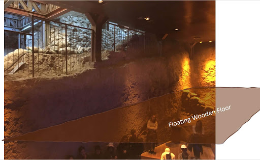
The discovery of rock-cut-rooms on the east facing, lower slope of Jerusalem's Mount Moriah, in proximity to the Gihon Spring may be Jerusalem's original temple, so called Temple Zero.
 |
| West end features including raised platform for altar |
The notable direction of Temple Zero is by the placement of its most important features including matzevah, or standing stone and raised platform, the remnant of its altar toward the west. Priests offering and attending to sacrifices on this altar would have faced west and wine or water poured onto the altar would have run in the liquids channel toward the pit on the east. Facing west obviated glorification of the sun, especially obvious during sunrise worship.
 |
| West to the matzevah |
 |
| West to the altars' raised platform |
Jewish religious practice does not permit the use of any medium or physical depiction as a conduit or substitute to a unified, omnipotent and directly approachable God. This premise dates back prior to the biblical record through establishment of monotheism. The practice transferred from Adam to Noah, to his son Shem known as Malchi-Tzedek (the Righteous King) and finally his descendant Abraham was the first to effect and teach the religious philosophy that was distinguished from the duality of paganism.
The bible prohibited post-Egyptian Israelite's from using a matzevah to covenant with God. Abraham's grandson Jacob was the last to erect such a stone at Beit El (Bethel) before the prohibition. Approximately 650 years after Jacob (Israel) was exiled to Egypt before King David returned the nation's central administration to Mount Moriah.
Practically the steep eastern slope is crowd unfriendly. The bedrock to the west rises (as seen by the retainer wall constructed for these excavations) and to the east falls away rapidly (as seen in the people walking up the steep ascent). Yet, by its very layout worship at this site did not pay homage to the sun. So, what was its purpose in context to the site of Solomon's first temple through the Herodian second temple further north on Mount Moriah?


 |
| East to the Kidron Valley |
From the great work of Israel Antiquities Archaeologist, Ortal Chalaf (standing @2 - middle image above) and Joe Uziel, we are fortunate to glimpse the ten times this space was built, destroyed and rebuilt over hundreds of years from the eighth century BCE to the end of the Iron Age (image @3). This evidences the tension between eagerness of and opposition to occupants that once heralded this sacred place. The biblical record at the end of the Iron Age reveals the fickle character of Jewish Kings who permitted or shunned idol worship in this period and the evidence at this location may directly reflect the Royal attitudes.
Remarkably, the matzevah has withstood the tests of at least 2800 years, from the earliest layer of construction and destruction above the bedrock. Almost certainly Temple Zeros' rock-cut-rooms precede the first layer built on the bedrock of the image @3, but was it in existence when King David arrived in the 10th century, ~200 years earlier? Most archaeologists agree that part of the fortified passage made up by Wall 109 (left) and Wall 108 (right) (see below) rises to intersect the bedrock ridge of the rock-cut-rooms and it dates to the middle bronze age.
 |
| Wall 109 and 108 and rock-cut-quarry block passage to Temple Zero (top center) |
The fortified passage was a major construction, involving imported, regional labor forces an event that is not recorded in the bible. Despite Joe Uziel carbon dating the north east tower corner, the complex is not considered to be a part of King David's early Iron Age activities. Reference to a pre-Solomon temple is also not mentioned in the 24 books of the bible, therefore a search for Temple Zero dating clarity should be directed to the Bronze Age.
Temple Zero's altar faced the sun, its priests were before the altar, with their backs to the sun. This opposed most, if not all idolatrous practitioners who otherwise would place their deities or human gods in the place of the altar facing the sun and priests before their deity, with their backs to the sun. Alternatively as with Christianity, priests were after (behind) the altar facing east toward the sun.
Is this the reason Temple Zero was relegated to a rock-cut-quarry (or pool) that blocked ascent from the east and a fortified passage that blocked access from the north-west? It did not celebrate deities or human gods and had no place for priests to practice after the altar, for idol worshiping occupants of ancient Jerusalem it had little use.
 |
| The holy center of Jerusalem opposed sun worshipers (Temple Zero bottom left) |
In the time before King David whether buried or blocked, even detractors of Temple Zero preserved its sanctity and the matzevah stands as a testament. Perhaps it was concealed so that its spiritual attractiveness to Israelite worshipers of a monotheistic God would be diminished or forgotten and with it their desire to return to The Mountain.