The Gihon Spring, near the Kidron Valley floor was ancient Jerusalem's only perpetual water source. It sustained Paleolithic, Chalcolithic and Early Bronze Age populations who lived in proximity to the valley until around 4000-3800 years ago. In the Middle Bronze Age, commensurate with Biblical Noah, Abraham, Isaac and Jacob populations migrated 50+ vertical meters further up the steep east facing slope to live on the mountains' ridge. For these occupants, access and secure passage of water, from the spring became crucial to successful survival.
.jpg) |
| Mount Moriah, one rock |
During the past 15 years several key discoveries have informed our knowledge of the eastern slope:
1. Cave K
Recent excavations identified a tightly packed, richly layered floor that should reveal information about the historical and chronological use of the cave. Work, presently underway indicates a usage spanning terminal Iron Age back to the Bronze Age. The cave was an important accommodation for occupants of the lower mountain. The cave exit/entrance, on its north-west end once connected with Passage XVIII that runs west, connecting Cave K with a rock-cut-temple around 10 vertical meters higher up the slope.
 |
| North Entrance |
Level crossing, from Cave K over the lower bedrock once provided convenient access to water from the Gihon Spring.
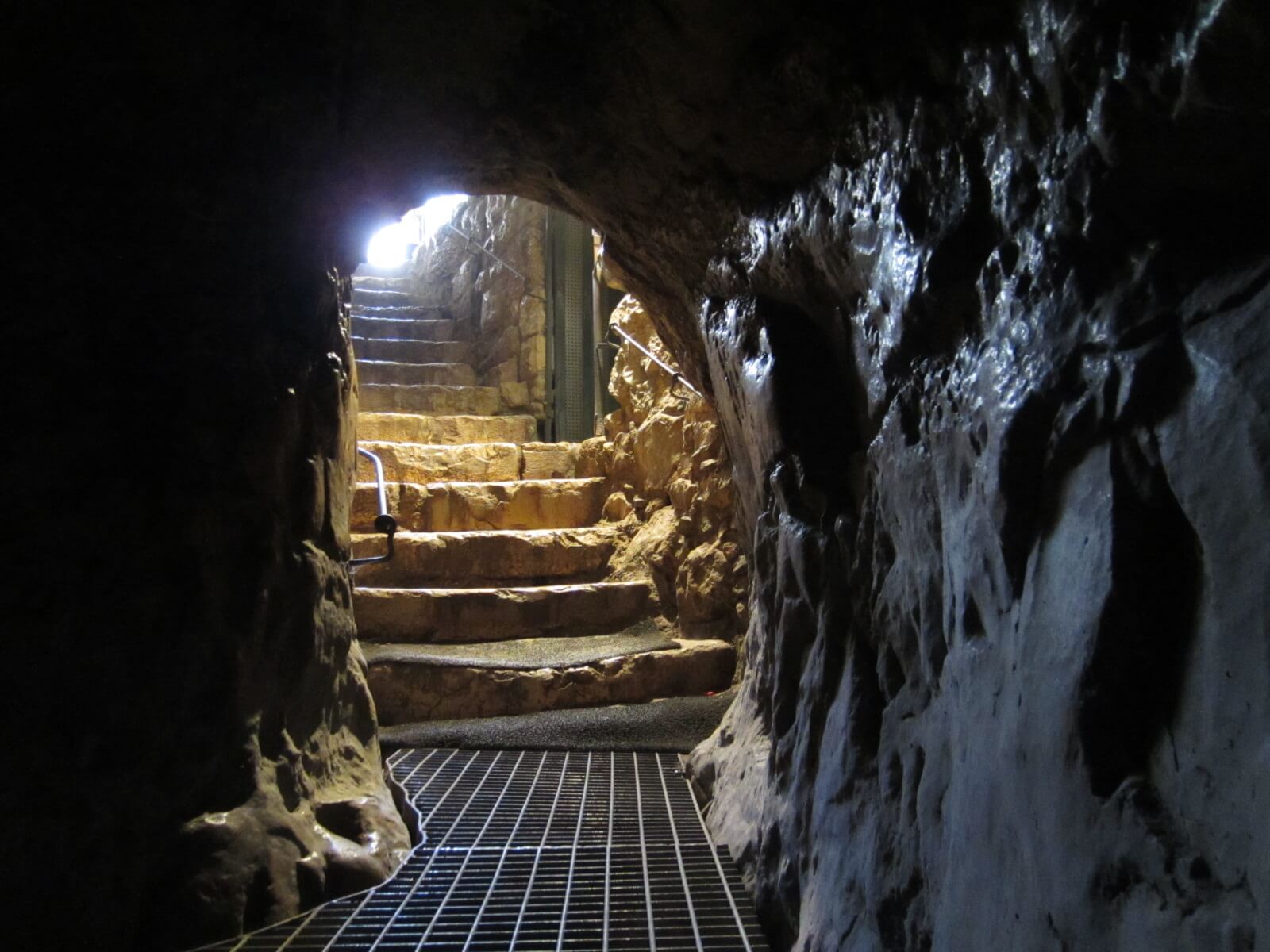
2. Passage XVIII
The remnant of this bedrock passage climbs up from the roof level of Cave K to the rock-cut-temple, due west, at a steep grade 10m further up the eastern face. The Cave K end of the passage appears to have been quarried or fissured and breaks lower level access to passage XVIII. Organic materials, found in mortar of a wall built in this passage was carbon dated to 3700-3500 years ago. This evidence aligned with similar materials discovered in a drainage channel along the west boundary immediately behind the rock-cut-temple. The organic material indicated that construction on the passage had occurred sometime during this period and provides evidence of its use during the middle bronze age.

3. Rock-Cut-Temple
 |
| Excavation to expose Rock-Cut-Temple |
This is arguably the most fascinating complex of Mount Moriah's eastern face. The temple cut in the rock contains all of the necessary elements for worship, similar to the practices that followed in King Solomon's First Temple as widely document in ancient Jewish texts. The features include (looking West);
 |
| Matzevah in the cabinet (left) - Altar Platform, liquids channel (right) |
.jpeg) |
| Matzevah |
 |
| Altar platform and liquids channel |
A Matzevah or standing stone was forbidden by Biblical law for use in any Jewish worship. Therefore, the practice ceased around 3300 years ago, some 300 years before King David arrived on Jerusalem's Mount Moriah. Prior to that, use of a matzevah was permitted as referred in Biblical Jacob and has been widely reported in archaeology. However, this humble matzevah is unique in all Israeli archaeology. The altars' liquids channel and altar platform once supported a stone altar on which animal sacrifices were offered.


To the left (south) of the matzevah 'V' cuts in the bedrock used for slaughtering, processing and preparing animal sacrifices. The room also contains a sunken mortar for crushing grains. To the right (north) of the altar platform an olive press for preparing pure olive oil, of the highest grade to be used for anointing and preparing baked sacrificial offerings.
.jpeg) |
| North over the olive press |
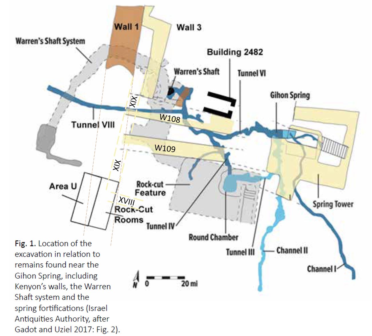
Looking north over the oil press, passage XIX is terminated by Wall 108 (see map below). The northern wall W108, of the double wall was excavated and dated along with W109 to the Middle Bronze Age. It is still unknown as to why the double wall was built and this remains one of the more perplexing elements of the temple complex.

A recent discovery (see image below) confirmed that the double walls abutt passage XIX, but that W108 (north, top of picture) extended through the passage further west blocking north-south access. W109 meets the passage and would have ensured foot traffic, between the walls, was guided to the south along passage XIX toward the rock-cut-temple complex.
 |
| Looking North, at the top, large steps between W108 (north) and W109 |
5. Defensive wall
As confirmed by surviving organic material, 1000 years after the rock-cut-temple were last used, toward the end of the iron age, a defensive city wall was built on the eastern face of the mountain. The wall was constructed over the rock-cut-temple and soft sand (discovered in 2011) was used to fill the spaces between the wall and the bedrock to protect the matzevah from damage by the heavy rocks of the wall. That decision, most likely by King Uzziah or Hezekiah, preserved the matzevah for 2600 years until it was discovered in-situ by archaeologist Eli Shukron in 2011. However, the wall constructors cleared the rock-cut-temple artifacts leaving only a small amount of Middle Bronze age pottery in the room adjacent to the altar.
.png) |
| Significant scale wall (looking north). Top right of the wall intersects W108. |
6. Question
If the rock-cut-temple was last used around 3500 years ago (the time of the surviving organic matter, particularly the remnant discovered in the drainage channel) it is conceivable the entire rock-cut-temple lay buried under earth and silt, unused for almost 1000 years before Hezekiah's wall was built, 2600 years ago in the lead up to the destruction of the first temple. The wall constructors would have exposed the rock-cut-temple, its artifacts and the matzevah causing the King at that time to decide what next? We now know that the defensive wall was constructed over the rock-cut-temple, but the constructors preserved the matzevah indicating respect and honor. If Hezekiah was king at the time and believed the matzevah were an object of idolatry his constructors would certainly have destroyed it.
On this evidence we must ask whether King David, who was compelled to this mountain, ever discovered the rock-cut-temple that existed 700 years before he became King?
2 Samuel 5:7–9 tells us; David conquered the “fortress of Zion that is the City of David,” after which he is said to have built “from the Millo inward”. The fortress David captured (thought to be the Spring Tower, see map above including W108 and W109) gave him full control over the precious water supply lines inward to the Gihon Spring. That's all it took to conquer the city 50m up the hill that was dependent on the Spring.
Did the 700 year legacy of priesthood and ancestral history, at the rock-cut-temple motivate David to capture and locate Zion? Did he ever find it?


.jpeg)