From the report by R. A. S. MacAlister and J. Garrow Duncan - Excavations on the Hill of Ophel, Jerusalem 1923-1925: "It will be observed that we avoided describing the vaulted rock-cut chambers as "cisterns". This has been intentional. We thought, when they were first uncovered that they were cisterns and in the original draft of this report we described them as such. We have now definitely abandoned this theory. There is no trace of a water line on the walls. There is no cup-hollows such as usually exists in the bottom of rock-cut cisterns to catch the last dregs of the water. We now hold that these carefully hewn chambers were tombs of a very early date, presumably belonging to notable of the Jebusite city. In fact we have come to the conclusion that there are no Jebusite cisterns at all in the city, but that the Jebusite city was dependent entirely on the Virgins Fountain (Gihon Spring and possibly other springs since dried up) for their water supply."
Shaft tombs were commonly used during the Middle Bronze Age to bury the dead, including in and around Jerusalem. They were generally constructed as a vertical shaft, cut into bedrock leading to a chamber at the bottom of the shaft where bones and valuable possessions of individuals or family members were laid to rest. Important people were buried in prominent locations where they had once lived, the scale of their burial commensurate.
Cylindrical Shaft Tomb
Prayer at the graveside of those who had progressed to afterlife may have been practiced similar to Jewish religion and tradition in Israel today. Cemeteries from this period are found scattered through Israel like the one in Michmash from the Middle Bronze age. Generally the tombs were constructed cylindrical, but sometimes rectangular or irregular shapes were built. Over extended periods of tens or hundreds of years populations at specific locations waxed and waned. Because of famine, pestilence, disease or wars shaft-tombs were often abandoned, which exposed the contents to vandalism.
Once tombs had been vandalized and emptied and with the passage of time as local inhabitants lost touch with lore of the deceased, they may have been used for other purposes. One such example could be the Round Chamber (named by lead archaeologist Ronny Reich) of the Upper Gihon Pool at the City of David, Jerusalem.
Upper Gihon Pool and Round Chamber in front of image (camera facing south)
The Upper Gihon Pool is immediately south of the Gihon Spring, from where it once received its water. The eastern rock-cut face, which is substantially lower than the other faces marked the pools maximum potential water line. Today the sunken walkway sits in the pool immediately adjacent (south) of the Round Chamber resembling the remnant of a cylindrical shaft. The top of the Round Chamber appears roughly honed suggesting its original deep cylindrical shaft preceded cutting rock away from it to form the large cavity of the Upper Gihon Pool. Since the lower height of the eastern face is the maximum water line, it can be concluded most of the cavity area was quarried for some other purpose.
Southern face of rock cut Upper Gihon Pool (camera facing south-east)
The southern rock cut face (seen above) of the Upper Gihon Pool expansion follows the original slope of the mountain as it falls east toward the Kidron valley. The cavity bedrock once filled the entire pool area. The Shaft tomb or deep cylindrical well of the Round Chamber was first cut from untouched bedrock. Later more rock was cut and removed to form the present cavity of the Upper Gihon Pool.
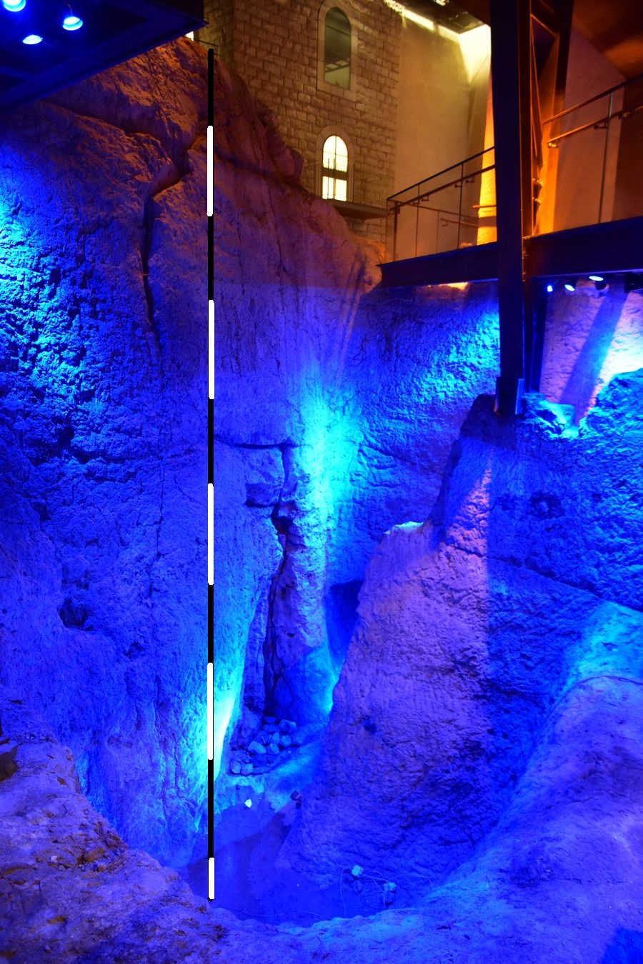
Yardstick in Round Chamber expanded in the direction of camera facing north-east
The yardstick in the image above illustrates the height from the bottom of the Round Chamber to the top of the northern rock cut face. The north-eastern Tunnel III (considered to be Middle Bronze Age) is visible and leads directly to the Gihon Spring. It is possible it once formed a Shaft Tomb burial chamber prior to widening the south-east side of the Round Chamber and the addition of steps into the pool (as can be seen in the map below).
Round Chamber - Shaft Tomb and east facing burial chamber
Entrance to the northern Tunnel IV in the image (bellow) is considered an Iron Age addition and may have been part of Iron Age efforts to dam water for storage within a few hundred years of the construction of the Siloam (Hezekiah) Tunnel.
View north-east to the expanded corner of the Round Chamber
In a previous post I identified the "other purpose" of the quarrying effort in the Upper Gihon Pool was entirely political. Specifically to stop Israel's access and to obfuscate the Middle Bronze Age, holy temple complex on the high, east facing ridge facing east, looking over the Upper Gihon Pool.
David Ussishkin’s alternative view is a wonderful account of excavations at the City of David on which many facts turn. Three references ought to be given greater weight because they fit the Biblical timelines.
Fill L1654A/1656A comprised the fill beneath the floor which also abutted Wall 285 (De Groot and Bernick-Greenberg 2012: 110, photo 130, plan 58). The floor yielded MB II pottery, including one complete, and two partly complete storage jars (Eisenberg 2012: figs 7.4–7.6, 7.12–7.14).
Hardly any remains from the Late Bronze or Iron I–IIA periods — structural remains and pottery alike — were uncovered in the Gihon Spring excavations (Reich 2011: 304–06; Reich and Shukron 2004: 213; Uziel et al. 2013: 24*). This datum indicates that, for some 800 years or so, between the end of the MB II in the 16th century and the Iron IIB in the 8th century, there was hardly any human activity in the area of the spring.
The presence of whole jars at L1654A/1656A is sufficient archaeological proof, by any standard that the floor post-dates the fill. The MBII pottery in the cave at the south-eastern end of the Warren’s Shaft System is sufficient to tie the period with L1654A/1656A, therefore the use of these features. Finally an 800 year gap in evidence at the Gihon Spring must surely be alluded to in the Biblical record.
According to Wikipedia, the Bronze Age and Iron Age together are sometimes called the "Biblical period".[9] The periods of the Bronze Age include the following:
Early Bronze Age I (EB I) 3330–3050 BCE
Early Bronze Age II–III (EB II–III) 3050–2300 BCE
Early Bronze Age IV/Middle Bronze Age I (EB IV/MB I) 2300–2000 BCE
Middle Bronze Age IIA (MB IIA) 2000–1750 BCE
Middle Bronze Age IIB (MB IIB) 1800–1550 BCE
Late Bronze Age I–II (LB I–II) 1550–1200 BCE
In the Iron Age/Israelite period both the archaeological and narrative evidence from the Bible become richer and much writing has attempted to make links between them. A chronology includes:
Iron Age I (IA I) 1200–1000 BCE
Iron Age IIA (IA IIA) 1000–925 BCE
Iron Age IIB-C (IA IIB-C) 925–586 BCE
Iron Age III 586–539 BCE (Neo-Babylonian period)
We can already see the discrepancy between Ussishkin’s “800 year gap” and Wikipedia’s 625 years. Give or take inaccuracies, that could be reduced to 550-600 years. In any event it’s a significant period where trace of life is almost non-existent.
Joshua 10:2-4 discloses that after news of Joshua’s destruction of Ai and secession by Gibeon , Adoni-Zedek, king of Jerusalem gathered neighboring kings from Hebron (south) Jarmuth (west), Lachish (south west), Eglon/Debir (south) to a battle they ultimately lost against Joshua.
The opening verses of Judges, 1:4-7 states the tribe of Judah brought Adoni-bezek to Jerusalem to die after he had been maimed by them. 1:8-15 briefly states Judah conquered Jerusalem. 1:17-19 states Judah also conquered Gaza, Ashkelon, Ekron and territory. 1:20,21 states Benjamin did not drive out the Jebusites who lived in Jerusalem. 1:22-26 declares the house of Joseph smote Beit El, which was Luz. Shortly after these accounts Joshua dies and the period of Judges begins.
I included Gaza, Ashkelon and Ekron to illustrate that the tribe of Dan, to which this territory was allotted was unable to occupy it fully and were forced to also establish territory in the north. Further, Jerusalem was split because Judah conquered Jerusalem, but Benjamin did not. Finally the question about the location of Luz must be addressed. Two potential locations exist for BeitEl/Luz, Jerusalem and to the north modern Bethel. If Jacob’s dream at HaMakom was Mount Moriah - Jerusalem, it would support that the following tit-for-tat verses are not declarative as to territorial achievements. In any event there appears to be empirical victory over some of Jerusalem, which may also be related to the area defined as Beit El or Luz.
Wall 285, to which L1654A/1656A abuts was a wall of the lower city on the south east slope of Mount Moriah, therefore it stands to good reason that this was the Jerusalem Judah conquered. It would also comport with Benjamin’s allotment to the northern section of Mount Moriah, designated Jerusalem. Curiously Judges 1:22-26 uses the adverb גם (gum) meaning also or further to the previous verse, regarding Benjamin's Jerusalem. As such BeitEl/Luz, which was smote by the House of Joseph forms a relationship between the verses and associates BeitEl/Luz with Jerusalem.
Returning to the absence of evidence at the Gihon, if indeed Judah or Joseph had destroyed the lower city of Jerusalem, it would necessitate that life ceased abruptly and that the ever present Israelite threat may have rendered the lower slopes of Mount Moriah uninhabitable for the entire ~440 years of Joshua through through King David.
The biblical account emphasizes that Ussishkin’s unusual absence of evidence associates the time of Joshua-Judges and suggests that use of the Warren’s Shaft System, following the Judah-House of Joseph attack on the lower city became the limitation on access to water, a significant factor that restricted the upper city's population growth.
I set out a theory and proof that ancient occupiers of the sparse hills of Jerusalem, with significant help from their regional allies constructed substantial elements of the Massive Fortified Corridor (MFC), adjacent to the Gihon Spring specifically to discourage Israel's return.
A conclusive theory of Jerusalem's Middle Bronze (MB) to Iron Age period continues to evade archaeologists and historians. One study by Hillel Geva tracks the development of Jerusalem's population and provides an excellent overview of the areas the city expanded to through the ages. I will use the breadcrumbs of population growth, as found in Middle Bronze age archaeology to reconstruct the first period of the city’s development.
Bewildering is the absence of any archaeological trace of a Middle Bronze western city wall in the presence of the MFC adjacent to the Gihon Spring on the eastern slope. Perhaps even more complex is the scant evidence of a complete eastern city wall, one that should have certainly left significant traces at intervals. I will demonstrate that the MFC was not constructed to protect water as per common logic, but to serve another motive.
The massive Middle Bronze II (MB II) fortress erected around the Gihon Spring undoubtedly required a
major economic effort and substantial manpower (Boas-Vedder 2001; Reich 2011: 248–261). This does not mean that the inhabitants of the city were necessarily the builders of the
massive structures; much of the manpower may have been recruited from the hinterland (Geva 2014). Although Uziel lead research to carbon date construction of the north-east corner of the fortress, an MFC extension to the Iron Age 800-900 B.C.E, there remains significant evidence that progression of construction from MBII to completion at the northern end may have occurred in the Iron Age.
Israel Finkelstein shares the view that the MBII fortress and area around the Gihon Spring remained somewhat independent of the expanded city. The old mound of Jerusalem was located on the
Temple Mount (Ophel) and activity on the City of David ridge
(the southeastern hill of Jerusalem) was restricted
to the area around the Gihon Spring (Finkelstein,
Koch and Lipschits 2011) In other words he supports the view that a complete MB II city wall, which has not yet been discovered, may not have existed at that time.
Figure 1 - Middle Bronze II - Warren Shaft System, Fortification and Gihon Spring. To align see (E) in Fig.2 below.
Coming out of the upper tunnel (Tunnel VI) moving to the eastern slope, a traveler finds
himself outside (north) of the MFC rather than on the path
leading into it, as one would expect if the corridor had already been built
before the Warren Shaft System (WSS). This indicates that parts of the WSS existed and part built before the MFC. Since the corridor is known to be Canaanite in age, it follows that
the WSS must also be of Canaanite age. (Dan Gill 2011)
With periodic increases in Mount Moriah's population (since the Early Bronze Age 1 - L.H. Vincent Underground Jerusalem) and geopolitical changes in the region, this hill eventually became one of the city-states that ruled in the region. In the face of the prevailing political rivalries from within and without, city rulers embarked on a comprehensive, state-funded, integrated program to protect the city and its vital water resources. Presumably, the city walls, the spring tower and MFC, as well as the Siloam Channel, were built during these stages. (Dan Gill 2011)
This invokes many questions, particularly related to evidence the Parker-Vincent expedition of 1909 uncovered, much of which has been principally ignored by Israel's modern archaeologists.
Figure 2 - Parker and Vincent map with photo overlay, sitting at position [K-21-b] (above)
An amateur researcher would be hard pressed to find any archaeological reference to Jerusalem's oldest private cave dwelling, but for a 1909-1911 photo of Parker and Vincent. This photo exposes [K-21-b] on the Vincent map, a private cave dwelling elevated ~20m above the valley floor on the eastern slope of Mount Moriah, south of the Gihon Spring. The cave dwelling (K) dates back to the early bronze age. It is barely referenced by Ronny Reich in his recent book Excavating the City of David - Where Jerusalem's History Began. Vincent also discovered pottery and tombs on the mountain that were dated to 3000 B.C.E. None of these finds date later than the Early Bronze Age.
I rely on the hypothesis that this initial private cave dwelling K was developed by and for important occupants because of its substantial size and features relative to the period of its construction. On this and evidence discovered in the immediate areas around this cave dwelling, I reconstructed the progressive development logic of population growth in the area.
Parker and Vincent excavated K as well as extensions L, M and passage N, adjacent to the more recently excavated area east of L, K, J and P. This area south of the, Rock-cut Pool(Fig. 1) forms an elevated platform ~3m above the top step that leads (on its eastern end) into the Round Chamber (within the Rock-Cut Pool) (Fig.1) also marking the lowest part of the expanded Rock-Cut Pool.
Figure 3 - Lower section of Parker and Vincent overlay map on Reich-Shukron Figure 1 map
Figure 3 is a rough context map of the entire complex including important elements missed by the Parker-Vincent excavation. The Middle Bronze age is a critical period in the development of this site, but the areas missed by Parker-Vincent, those (south) adjacent to G were excavated by Shukron in 2008-10. The most recent excavations (the circled area) are fundamental elements in the logic of these staged progressions.
The birds eye view in Figure 3 includes (what was) an impassable access corridor rising from lower elevation J-P to a temple complex on high ridge G-H. In area F (lower level) excavation reached the bedrock and exposed a number of steep bedrock steps, on several of which were potsherds from Middle Bronze Age IIB. (Shukron, Uziel, Szanton 2013) and Kathleen Kenyon's trench excavation immediately north of Wall 17 revealed potsherds dating to MBII (Reich).
The mapped complex of Fig.3 at the City of David. Kidron Valley foreground. Orange line - a potential path across the bedrock escarpment to between Plateau P and upper ridge sections
Kathleen Kenyon's Wall 17 on bedrock north of Temple Complex on upper ridge
The descending section of the east-west corridor marked XVIII, at lower elevation P-XXI appears to have been disconnected such that its eastern end (as it approaches P) terminates as a sheer rock face that rendered the upper part of the corridor inaccessible. The missing section may have once connected this steep corridor between lower and upper elevation. (see image below)
The impassable, disconnected corridor. Lower-eastern section has been reconstructed to connect P with G
Following the logical path from C to E to G (including via external passage at E) a well thought-out plan was implemented to improve upon natural
karstic elements and combine them into an accessible water supply system that became known as Warrens Shaft, (Dan Gill). Although the complex of rooms excavated at G were completed by 2011, no archaeologist report has ever been published, but the temple features of this complex overwhelmingly support its spiritual importance.
Returning to the Rock-cut pool of Figure 1, the MBII channel and Round Chamber preceded the expansion of the pool to its present day boundaries (Reich attributes this expansion to the Iron Age). The eastern stepped access into the expanded pool and more humble Round Chamber suggests the Chambers original elevation may have once been level with adjacent plateau's north and south (as indicated, by red outlines in Figure 4 below).
Figure 4 - Shukron, Uziel, Szandton excavations enhanced and labeled
Looking (south) over the Round Chamber, tourist walkway sunken into Rock-cut Pool.
Fallen boulders (right-west) illustrated green in Figure 4
Figure 5 - Indicative depth of original Round Chamber edge (north-east) level with northern adjacent plateau and entry of MBII Tunnel III
Round chamber entry of Iron Age Tunnel IV (left) and MBII Tunnel III (right)
The expansion of the Round Chamber into the Rock-cut pool, which disconnected the lower section of corridor P-G would have rendered the P plateau and cave dwelling K inaccessible from its opposite northern plateau (that supports the remains of MFC - Fig.5). Further, the high ridge of area G would have become inaccessible from any of the lower reaches on the eastern slope of Mount Moriah and the Kidron Valley. This or any renovation may have occurred at a date later than MBII, perhaps very Late Bronze (LB) or Iron Age (IA) (Reich).
In the video above Ronny Reich confirms that Middle Bronze Age access to water in the Round Chamber would have been via WSS to the MFC plateau (before the MFC was built). The cave’s opening is sealed but may have been accessible in antiquity (Uziel). At the same level, MFC plateau was level with and part of the P plateau. Quarrying the the Rock-cut pool and construction of MFC would have cut internal access between the WSS and plateau P.
It would have been convenient to quarry and extract the rock surrounding the Round Chamber to form the Rock-cut Pool in order to construct the MFC on its adjacent northern plateau. Was this part of their thinking? The deep chasm of the Rock-cut pool cut access and the added MFC divided the entire mountain to the south placing more emphasis on north-west expansion of the city. This is further evidenced by the existence of wall constructs that blocked access along Parker corridor XIX at the point the fortification corridor abutted city walls that were constructed in the Late Bronze or early Iron Age.
Having been slowly established during the Bronze Age on the lower, southern end of the eastern face of Mount Moriah, people, who were now more technically capable were on the move to expand the walls of the city north as the Iron Age was gathering pace. If we accept the hypothesis that this was the pattern by which Jerusalem became more populated then we can understand this atypical development model for a location so prominent in history. Atypical because countless archaeologists who have worked on or studied these excavations coalesce that water protection was the motivation for fortification around the Gihon Spring, but I suggest this was not the case.
The effort to quarry the Rock-cut Pool and construct adjacent fortification corridors that cut the eastern slope, separating south from north was herculean (Boas-Vedder 2001 and Reich 2011). Regional labor, at subsidized cost would have been imported to the city, but only if the ~900 inhabitants (Geva) of MB Mount Moriah had good reason to inspire and undertake such significant development. Note: The Rock-cut pool is cut deeper on the southern, northern and western edge. Storing water was not the reason for these deep cuts because the eastern edge, perhaps as much as ~2m lower dictated the highest water level in the pool.
Given Dan Gill's observation "...that Coming out of the upper tunnel (Tunnel VI) to the eastern slope, a traveler finds himself outside (to the north) of the MFC rather than on a path leading into it...", protecting water does not seem to have been the objective of the MFC construction. Although Early Bronze developments may have cast the die, at any reasonable MB, LB or IA date, geopolitical objectives must have been strongly aligned to inspire regional powers to support the construction of such a substantial infrastructure push to the north.
In summary we have structural evidence of;
1. a deep cut quarry on 3 sides of the Rock-cut Pool leading to Round Chamber
2. access impasse from rock plateau supporting MFC to plateau of cave dwelling K
3. eastern city wall's or foundations but not western
4. fortification corridor blocking XIX and abutting an eastern city wall north of G
5. disconnected corridor joining P with G
6. misalignment of fortification corridor south of and adjacent to the Gihon Spring water source
On the high ridge at G the stone-cut, beam, oil press is juxtaposed with the undisturbed matzevah or massebah and rock frame (see matzevah image below) that was placed directly on the bedrock at some point after the stone-cut rooms had been completed.
A 2013 excavation along XIII west of G unveiled a weight which may have been used for the oil, beam press as depicted
Dating of the rooms carved on the high ridge could be as far back as Early Bronze IV such that the development chronology on the mountain may resemble the following.
1. Early Bronze I
– 3300-3050 B.C.E. – sparse, periodic settlement
2. Early Bronze II-III
– 3050-2030 B.C.E. sparse, prolonged settlement including private dwelling K
3. Early Bronze IV/Middle Bronze I
-2300-2000 B.C.E. - permanent settlement, bedrock chiseling at high ridge
4. Middle Bronze IIA 2000-1750 B.C.E
. – expanded settlement, early use of area G high ridge, expansion of WSS, Gihon tunnels
5. Middle Bronze IIB-C 1750-1550 B.C.E.
– excavation of Round Chamber and expanded area G features constructed on the high ridge
6. Late Bronze I – 1550-1400 B.C.E.
– development on east face, commencement of city walls
7. Late Bronze IIA-B 1400-1200 B.C.E.
– commence construction of city walls, Rock-cut Pool and MFC
8. Iron Age I 1200-1000 B.C.E.
– completion of MFC, expansion along valley floor, tower and city walls
9. Iron Age II – 1000 – 586 B.C.E.
– water system rearrangement, internal city construction, expansion North and eastern outer wall
At some point after the construction of rock-cut rooms at G, perhaps MBI or MBII the matzevah discovered by Shukron would have been constructed on the bedrock at G.
Matzevah at G
An inventory of items located north to south in 4 rock-cut chambers at G (see southwest corner in Figure 4) include;
1. beam, oil press (external east wall of animal pen)
2. small animal pen (room enclosure)
3. altar platform, grain press, liquids channel leading to pit (tunnel exit west)
4. animal ties (thread through rock corners)
5. matzevah (see picture above)
6. grain press, oil press, V markings in bedrock floor (exit tunnel west)
Eli Shukron in the now famous room with V markings exit tunnel west in the north west corner of room
The significant rock-cut and matzevah features in the chambers at G indicate, at least MB use as a temple for high volume worship. Its large scale construction on the high ridge overlooking the Kidron Valley once announced its importance. The scant population of Mount Moriah cannot be have motivated such a significant rock-cut construction, therefore it is more likely it's location and cultural importance attracted people from the region that motivated its construction. Given the dominant nature of this early element of the scheme in Figure 3 especially its relationship to the southern end, it is surprising that the Rock-cut Pool and MFC cut the eastern slope, obfuscating access to area G's rock-cut rooms.
Curiously the next Figure 5 scheme of excavation presents corridor 1,2 and 3. We have discussed corridor 1 previously as the east-west disconnected P-G corridor marked XVIII in Figure 3. However, corridor 2 terminates at the western deep cut edge of the Rock-cut pool and corridor 3 terminates prematurely into an apparent dead-end. The evidence suggests access to the water below from the temple on the high ridge at G was important. As demand for access was growing additional corridor excavation may have been undertaken. Nevertheless, these excavations are incomplete and 1,2,3 defined here as corridors may simply follow the bedrock slope to their termination points.
Figure 5 excavation area scheme with G and matzevah as indicated - click to enlarge
Relying on the structural evidence above and stratum data provided in the references used, we must establish credible reasons why;
1. the Round Chamber was quarried to establish the Rock-cut pool
2. lower vital connecting sections of corridor 1 (P-G @ XVIII) were cut and corridor 2 terminated at the western quarry edge of the Rock-cut pool
3. the MFC adjacent to the Gihon Spring was undertaken.
Therefore, I posit the following chronological hypothesis;
1. That Mount Moriah was settled in accordance with 1-3 of the chronology above during EB.
2. That MB I reasons for permanent settlement began to materialize, but that these were not fundamentally based on demand for water, but on soft-cultural, spiritual demands as evidenced by Geva's population estimates.
3. That cave dwelling K and early features of the temple at G began servicing spiritual demands
4. That the Round Chamber and channel from the Gihon Spring were constructed to service increasing transient demand during MB IIA-B
5. That the matzevah was erected during MB IIB-C
6. That eastern walls, the Rock-cut pool and MFC were constructed toward the end of LB
Finally the reason for MFC and Rock-Cut-Pool were entirely geo-political, they served little practical purpose. At least the MFC and eventually the Rock-Cut-Pool was entirely required by regional leaders to cut the eastern slope and access to the Bronze Age temple on the high ridge at area G. The next video supports my claim.


