Translate

Showing posts with label abraham. Show all posts

Thursday, July 11, 2019

Report from City of David

After living in exile in Egypt for 210 years and after wandering the desert for 38 years, Israel sought to enter the land of its inheritance. To their surprise Amalekites disguised as Canaanites attacked them, Edomites refused them passage, Moabites and Ammonites withheld food or water. All these events took place on Israel's southern approach, along the eastern side of the Jordan river and are recorded for posterity in passages of Chukat (Numbers:20-22) from the Bible.

What inspired these independent nations to collaborate against Israel? In absentia, Israel should not have deserved their collective, ill treatment or designation as enemy of their various states. Yet, they unanimously stood against Israel's attempt to reach its destination. The threat of Israel rising must have been a significant motivating factor that contributed to this coordinated national resistance.

If we use the Bible as a context, Israel's redemption from exile in Egypt must have seemed like the impossible come true. This fledgling nation of 70 had grown to an army of 600,000 men and now their families were amassed along the south eastern boundary of the Jordan River. The daunting prospect should have dampened the conviction of the alliance against Israel, yet each nation stood resolute against them.

This article is not about the war that ensued, during which Israel conquered the land of Moab, Amon and the Amorites east of the Jordan river instead it focuses on the ultimate destination, the mountain that motivated Israel's allied opponents to remain united and intransigent.

Some 300 years after these events, there was good reason King David waited for 7 years, after his inauguration, before he could advance on the mountain from which he would ultimately establish the united kingdom of Israel. The mountain, is ancient Jerusalem's Mount Moriah associated with some of Israel's most significant events during establishment, and post redemption from Egypt. Israel's preamble, as recorded in the Bible and commentaries preserved over multiple millennia include stories of, Adam, MalchiTzedek, Abraham, Isaac, Jacob, Joshua and, David followed by a 1000 year lineage of kings. So, why was conquering the mountain a go-no-go event for David and why did he risk his fragile kingdom to capture it?

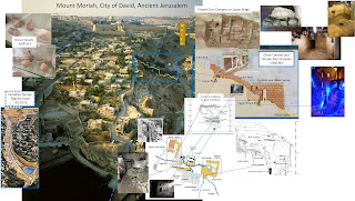
To answer that I offer the following pictorial study of the early through late bronze age (4000-3300 years ago) artifacts that preceded King David (3000 years ago) on Mount Moriah.

Inside cave home on the
 lower eastern slope of Mt Moriah

Passage out of cave home,
north to steel steps

Early bronze VIP pottery
discovered by Parker

Connection from top of 
cave home passage to upper ridge


Connection arrives at upper
ridge altar and liquids channel


Upper ridge - bedrock
 and steel cabinet
Standing stone/pillar
or matzevah on upper ridge


Oil press on upper ridge
 (north end)

V-markings on upper ridge
(animal processing - south end)


Double walled fortress of Zion
south of Gihon spring
View from upper ridge into
the double wall fortress of Zion

 More at this interactive map 

By the end of the Middle Bronze Age the massive double wall of the fortress of Zion was built up the steep eastern slope of Mount Moriah. It was an enormously complex feat of architecture and engineering for that time. It could not have been accomplished by the small local population alone. They must have obtained the full support of the alliance and there must have been a deeply rooted reason for allies to dedicate the resources required for its construction. The water of the adjacent Gihon Spring was not directly protected by its construction and could not have served as the reason for it.

The artists rendition of the King Solomon Era, eastern slope of Mt Moriah, demonstrates how the double wall fortress of Zion circa 3300 years ago (400 years before Solomon) may once have cut access across north-south directions on the eastern slope. The city wall, circa 2700 years ago, was  added before the destruction of the first temple.

The ~2700 year old city wall can be seen
in the upper section of this image on top
 of an older wall connected to the bedrock

Connect the blue plastic to piece together
remnant of the southern element of the
 double wall fortress of Zion

Apparently the allied forces opposing Israel did not want Israel to come back to the mountain and particularly this section on the south eastern slope. But, why did King David make sure to conquer this mountain, at this location in order to unify his kingdom?

The area was once known as Luz, Salem previous to that. It was the area that Malchi-Tzedek practiced as high priest, where Abraham tithed to him, where Isaac was offered as a sacrifice and Jacob erected the pillar, standing stone or matzevah. For these reasons Israel's allied enemies were intent on permanently isolating the bedrock temple discovered at this location and they did all they could to ensure the impracticality of its use. They allowed it to be buried under natural ground cover and defended against Israel's attempts to reoccupy the location. By the time King David conquered it, 300 years after Israel's return, the bedrock temple on the upper ridge was out of site, buried deep under ground. These are my opinions, I invite you to form yours!


Monday, May 6, 2019

From Missiles on Sderot To a Terrorist in Poway

Missiles fired from Gaza to Sderot
In everything there is a lesson to be learned as the Israeli family from Sderot who recently moved to Poway, California discovered.

The elderly Isaac became blind because, as is warned against in the Gemara (Megila 28) he had too often gazed into the eyes of his evil son Esau. Isaac's good son Jacob on his return, after 20 years in exile was injured in his hip, lamed in a battle with the angel of his evil brother Esau, who bestowed on him the name Israel for prevailing over him.

The Gemara added that Avimelech, King of the Philistines cursed Isaac's mother Sara, when he found out that she was the wife, not the sister of Abram. Commentary about the curse centered on the word K'SooS[T], which normally means a garment, but suggested punctuation on the same letters could have rendered the word K'SiyaS[T], which would mean a cover - over your eyes. Its use in a curse would have meant to loose your eyesight, which is what had happened to Sara's son - Isaac. The Gemara accepts both reasons as valid.

After Avimelech's shepherds attacked Issac's wells, Isaac agreed with Avimelech to extend his father Abraham's peace-pact permitting all future decedents of the Philistine King to reside in the land of Isaac's inheritance.  But, peace with the Kings antagonistic subjects was short lived, fragile at best. For his weakness in pursuit of improbable peace, Isaac was nick-named - "The Blind" and after Jacob returned to the home of his father the antagonists nick-named him "The Lame" because of his injured hip. Together they became known as The Lame and The Blind!

The coast in Aza, today known as Gaza, was once home to the Philistine antagonists. But, 10 Kilometers east, along the ridge of central hill territory their antagonist cousins occupied Isaac's inherited land spanning north from the Town of Four (Kiryat Arba) to Mount Moriah. Not long after Isaac's death, Jacob and his family of 70 escaped severe drought by immigrating to Egypt leaving behind the land he inherited, but had struggled to possess.

Mount Moriah (looking north) - Jerusalem - time of Joshua 
For the entire 210 years of Israel's sojourn in Egypt the antagonists were free to spread their occupation and entrench themselves in the important cities of Kiryat Arba (which is Hebron) and Jerusalem on the lower southern slopes of  Mount Moriah. Empowered, by their false beliefs narratives of The Lame and The Blind became entrenched in their antagonistic cultures as they mocked Israel.

Egypt provided a protected environment for the family of Israel to flourish. Jacob's son Joseph, who preceded their arrival had been empowered as the Egypts viceroy which provided the basis for the fledgling family of Israel to spread their influence. The family grew to millions, but toward the latter years, after Egypt's Pharaohs turned against them the path was established for their return to the land of their inheritance. Egypt's political alliances followed their direct family relationships to the Philistines along the Mediterranean coast and cousins to the inland mountain ridge, where news of Israel's rise against and threat of departure from Egypt spread.

The central hill antagonists anticipated Israel's return to their beloved Mount Moriah, the source of their inheritance:- The place, Noah's son Shem had practiced as the high priest of Salem, to whom Abraham had tithed his wealth, from whom Abraham descended:- The place Abraham had offered his son Isaac as a sacrifice :- The place Jacob had erected a standing stone, pillar or matzevah as a covenant to build the House of God. Intent on stopping their repossession, the antagonists lobbied their regional allies to provide labor and skilled stonemasons to erect a massive structure up the eastern slope of Mount Moriah and block the sacred places that Israel would no doubt seek on their return.

Quarry - cutting access across eastern slope of Mount Moriah
To the sacred place on the eastern slope

Quarrying massive stones from the adjacent rock plateau, they hacked Mount Moriah's lower, eastern mountain-side to ensure any prior access to the sacred places was forever impassable. One by one massive cut-boulders were lifted on top of each other progressively rising from valley floor up a steep slope to the most sacred place, 120 meters above the valley floor. The massive structure resembling a ziggurat, an ascending stepped structure and the quarry remnant would forever alter the landscape of the once naive, east facing slope of Mount Moriah.

The first of Israel's spies to return to this place could not believe what they saw. Their experience with the pyramids in Egypt must have led them to believe such similar structure on Mount Moriah was beyond human. It shook them to the core, shattered their confidence, motivated them to publicly express anxiety, report dangerous tidings and ultimately delayed Israel's return to their land by 40 years.

When Israel under Joshua finally entered the land of their inheritance and made their way to Mount Moriah, the antagonists were waiting on the very structure they had constructed in preparation. From their strategic vantage point they beat on drums, threw stones,  displayed their idols and shouted reminders that Israel, the ascendants of The Lame and The Blind had an obligation and responsibility to honor their pact with the central hill antagonists and their Gaza kin. It took 300 more years before a brave King David (2 Samuel 5:8) finally antagonized the antagonists in a manner that induced their co-existence.

Rabbi Goldstein on the White House Lawn
Like those before them, today the antagonists of Gaza antagonize their neighboring Israeli residents with a constant barrage of missiles on places like Sderot. Israel cannot hide from antagonists, only their constant strong-arm, offensive, counter-antagonistic strategies will mimic the tactic of King David to neutralize the behavior of antagonists who otherwise will forever recall the curse of Avimelech. Israel must adopt the attitude of the Rabbi of Poway, who avenged the dead and injured to change the curse of terror to the blessing of peace!


Wednesday, November 7, 2018

The Place Jacob Stumbled and Became Israel

Of 79,847 words in old testament Hebrew Bible, "va-yi[Ph][G]ah" is used once to describe the manner in which Jacob came upon a certain "place" [Ba MaKom] Genesis 28:11. It is also used once in the Book of Samuel and three times in the first book of Kings. In the latter books it expounds the murder of priests and retribution against a traitor. So, how does the murder of priests by Do'eg, who was a conniving, ruthless teacher of King David and retribution by Ben'ayahu ben Yehoiada, for the King relate to Jacob's experience at the place?

The verb "[Ph]-[G]ah" means to encounter, meet or reach, perhaps encounter (as in strike can relate to killing or murder. However, because a softer verb was not used commentators interpret this long memory, encoded into the Bible's Hebrew words as if to his surprise Jacob, fell upon, collided with, or stumbled onto the place.

Regular readers of this blog know that the standing stone or matzevah in ancient Jerusalem's temple zero complex (see image below) may be the one Jacob erected the morning after his "va-yi[Ph][G]ah" experience which was followed, that night by his famous 'stairway-to-heaven' dream.

Four room temple complex on Upper Ridge above the Gihon Spring

Of the four rooms discovered in the temple complex, on the eastern face of Mount Moriah the bedrock at the western end of room 2 drops to a low point around 1 meter above the ground. This apparently natural feature outlined in red and immediately further west in green (in the images below) illustrates the fall of bedrock toward the ground level bedrock. The standing stone (also in the images below) is not depicted in room 2 (above) to illustrate that it was erected on top of the ground level bedrock well after this temple complex had already been constructed.


Looking west into Room 2 

Only the raised bedrock platform at the rear (west) end of room 3 was purposely left in place when the original constructors shaped the bedrock into these four rooms. The image (below) of room 3 bedrock floor contrasts the liquids channel (left of image) carved into the bedrock floor from retained (top rear) raised altar platform. This serves to emphasize the purpose of the construction as a temple complex from the outset.

Room 3 altar platform left in place when rooms bedrock was removed to shape rooms

The man-made-wall in the background, west of the green outlined bedrock (below) was dated to the time of King Hezekiah by various archaeologists. Around 1000 years earlier, toward the end of the middle Bronze Age the man-made-wall did not exist, but the bedrock features of rooms 1,2,3 and 4 did. We know that because pottery artifacts discovered in passages immediately east and north of these rooms are dated to the middle bronze age and chisel markings are indicative of that time. 

Matzevah or standing stone at the rear, west end of room 2
Further west of the man-made-wall bedrock continues under the wall, as seen in the image below. In the middle Bronze Age, before the man-made-wall was built bedrock access to and from the west of the temple complex would have been a more gentle access route. The grade of the east facing slope seen in the following image supports the idea of gradual access.


The man-made-wall  (City Wall in image below) approximately demonstrates the relative position of the four room temple complex on the Upper ridge in context to the City Wall at the site of the excavations. It also illustrates the proximity of the Upper Ridge temple complex to the water of the Gihon Spring in the Kidron Valley below.


For those who are familiar with the Bible story of Jacob: On the run from his brother, Jacob made his way to (Genesis 28:11) the holy place of his ancestors (Mount Moriah) where his father was once offered as a sacrifice by his grandfather whose homeland Jacob was about to leave behind. When the sun set he stumbled upon the bedrock and fell into room 2 of the temple complex. That night he packed stones around his head, which he took from (the ramp of the altar in) room 3 and exhausted he fell asleep. In the morning when he awoke, he erected the stone and anointed it (Genesis 28:18) and after twenty years in exile he returned back to it (Genesis 35:14). I maintain that this is the place Jacob was seeking and this is the place Israel is still seeking, perhaps one day we will all find it!

Sunday, August 12, 2018

Jerusalem's 'Temple Zero' Predicament!


The southern room - animal processing and grain press
The lead archaeologist says its Middle Bronze Age, but the tour guides say Iron Age and the Antiquities Authority is silent? For the uninitiated that’s an impossible gap of 600 years!

In 2011 lead archaeologist Eli Shukron discovered 4 hidden bedrock rooms preserved by a false wall. They feature an altar, a grain press, an oil press and a stone monument known as a matzevah. Low loops chiseled through corners of bedrock were once used to tie small animals before they were sacrificed. He openly attributes the rooms to MalchiTzedek’s Shalem, but the matzevah he unwittingly says cannot be Jacob's because"...we're talking about Jerusalem...” (See the video @7:40).

The matzevah of Jacob
This is where Eli and I diverge. Jacob’s matzevah was erected at a place he called Beit El, which according to the clearest geophysical reference in the bible (2Kings 23:4) is on eastern face, on the southern end of Mount Moriah, Jerusalem. Exactly at the location in this blog-post! Eli falls victim to the confusing arguments promoted by Jeroboam after King Solomon built the first temple at its alternative location on Mount Moriah.

The ramifications of Eli's statements strengthen me to overcome ignorance, which I justify because archaeologists are not biblical scholars nor the alternative. Who can blame them? However, the City of David has a far greater responsibility to reveal facts. Jerusalem's "temple zero" predates King David so why didn't he identify these rooms as the location at which his son Solomon would  build the first temple further up the mountain?

If you're fortunate enough to visit this place, tour guides may tell you King David built it to house the Ark of the Covenant during the 37 years before the first temple was built. Or that the rooms already existed so he brought the Ark here to rest and this is where he built a tent to house it. But, nothing in their explanation addresses why King David would permit a matzevah, a practice abolished in the bible ~350 years before him. Worse, they won't tell you of the Middle Bronze Age evidence that predates King David to Jacob, Isaac, Abraham and MalchiTzedek. They promote confusion by saying things that are not helpful to absolving ignorance.

The simplest answer is that King David never found these four rooms. However, someone after him, in the mid-late Iron Age did because Middle Bronze Age evidence was found in the area surrounding these rooms, but the rooms had been filled with soft sand, preserved and cleared of Middle Bronze Age evidence.

I've written extensively about these rooms, you can explore my blog for more, but Jerusalem's Temple Zero predicament challenges interpretations of Jewish law and tradition that preceded King David. Fundamentally, if this is Jacob's Beit El then established ancient traditions also declare it to be the site of the future, final temple, which competes with present views and raises questions that may be too hard for people to answer.


Sunday, July 29, 2018

Stop the "fake news"!

Moses was told to gaze west, north, south and east (Deuteronomy - 3:27) similarly Jacob (Genesis 28:14), but Abram was told to look north, south, east and west (Genesis 13:14). The Me'Am Lo'ez says; one would expect east to be mentioned first since this is the direction of sunrise. However, Abram, their predecessor was in BethEl where the future Temple would be built.

About the whereabouts of this location, only one defining statement in all the 24 books of the Bible exists. Undisputed, 2Kings 23:4 states BethEl is the lower south-east slope of Mount Moriah, adjacent to the Kidron Valley in the City of David archaeological park, which is ancient Jerusalem from before the time of King David.

For more than 300 years Israel's tribal logic was dominated by Ephraim's envy over the southern boundary Benjamin shared with Judah, the location Abram was standing. Following King Davids ascension to Jerusalem and unification of the tribes, his son Solomon built the temple at the location. But, one generation later the exiled Jeroboam became King over a divided nation and established a temple of idolatry at Bethel, which is ~20km north of the location at ancient Jerusalem. The nation remained divided since that time.

Significantly, Jeroboam's actions left Israel confused until today. In northern Bethel, Professor Hagi Ben Artzi, the brother of Sarah Netanyahu argues it is the place Jacob experienced his famous dream of a stairway between heaven and earth on which angels were ascending and descending. And, archaeologist Eli Shukron argues the matzevah (monument) he recently discovered at BethEl, the location of Abram cannot be Jacob's because he was in Hagi Ben Artzi's Bethel (to the north) (see Eli @7:40 in the video below). 


The confusion has become endemic and logic circular causing many investigators to justify the ancient city of Ai  must also be ~20km to the north because that's where Bethel was and Abram is said to have pitched his tent between these two locations (Genesis 12:8). Despite the ancient city of Ai never being discovered academics happily defend their entrenched views.

Few have stopped to consider ancient Jerusalem is Mount Moriah, Salem of MalchiTzedek (Noah's son Shem), BethEl of Abram who became Abraham, akeida of Isaac, Luz and BethEl of Jacob's matzevah, Zion of King David and the Temple of King Solomon. Further that Abram could just as easily have pitched his tent opposite BethEl at the site of a Benedictine Monastery that is today a guesthouse called Maison d'Abraham - the House of Abraham. Finally that Ai could have been east of Maison d'Abraham toward the village Jabal Batin Alhawah.

Maison d'Abraham opposite BethEl in the reclaimed City of David.
Regardless, the irrefutable evidence that Eli Shukron discovered in 2011 is too impact-full to uphold the confusion that has permeated our logic for thousands of years. The temple complex in which the matzevah is located predates King David. Middle bronze age artifacts in the adjacent surroundings, the stone cut rooms of bedrock, preservation of the altar platform, liquids channel, oil and flour press are far too compelling to endure prevailing confusion. Further the middle bronze vessels found under the stone floor of homes built in the perimeter wall of the lower south-eastern valley floor, establishes occupation to the time of Abram. 

This enlightenment firmly establishes a path to realize this location. It is repeatedly referred in the Bible, a living text that is archaeologically established for at least 2300 years. It serves as Israel's permanent record which governments will be formed to express and a King appointed to realize Jerusalem's temple at this location that screams out for it.


Sunday, November 19, 2017

Ancient Chronology of Jerusalem's Holy Rock

As updated October 2018

Believe it or not, you are looking at Jerusalem's Mount Moriah. This once deserted mountain, nested among others is one rock from top to bottom between an eastern and western valley. On its lower eastern face, near the water of the Gihon Spring its first permanent cave dwelling, a living space with three sleeping quarters was carved neatly in the mountainside rock. A narrow single access passage provided a concealed entry for its inhabitants. The dwelling must have passed through generations, but the periodically and sporadically occupied mountain mostly remained desolate and the cave empty of inhabitants.


Mount Moriah looking North

Bronze Age Cave Home

An important spiritual practitioner, perhaps an oracle, a priest and healer occasionally attracted visitors. Higher up the steep east facing slope, a ridge, a platform overlooked the water of the Gihon Spring as it ran along the Kidron valley floor. It became the meeting place for worshipers and advice seekers. Temporarily dwelling on the mountain they sought advice, prayed, brought sacrificial offerings and moved on.

Bronze Age artisans chipped away the bedrock of the ridge on the eastern face until hollow spaces formed depressions in the rock. The depressions were enlarged, shaped into rooms exposed to the sky. More rock-on-rock workmanship eventually smoothed vertical walls from the hollowed spaces, until the depressions became rectangular and bedrock walls arose from the bedrock floor that had been lowered by the artisans.

A low bedrock platform in room 3 was preserved by the artisans, it is the foundation of an altar and supports the holy purpose of the 4 rooms . Two rooms (1&3) preserved access to the rear (west), rising, undulating bedrock ridge, perhaps to facilitate movement of people, supplies or animals to be sacrificed.

Temple Zero complex on the high ridge

Archaeologist recently revealed that the openings in the rear (west) of room 1 and room 3 provided access to the rising bedrock (follow green arrow in images below). Iron Age houses were built on top of the rear bedrock, but the evidence uncovered proved they were destroyed during events of the Babylonian conquest of Jerusalem. Their rudimentary basements penetrated to the spaces, near bedrock, at the rear of room 1 and 3, but their occupants never accessed these four rooms because in 2008 Eli Shukron discovered these rooms had been purposely buried in soft sand, concealed by a false wall on their eastern front, which he deconstructed.

In the rear opening of room 1, clay weights, once used as part of a weaving loom were discovered (Ronny Reich). Immediately north of this ridge Kathleen Kenyon excavated a trench behind a Middle Bronze Age wall in which pottery shards and hundreds of broken artifact idols were uncovered, but her dig did not discover these rooms.

Green Arrow (left) leads from the opening in rear of Room #1

The features chiseled into the bedrock were confirmed to have been made by rock implements and may have been added progressively. At some point after completion of room 2, a unique matzevah (massebah) or standing stone was placed onto the bedrock. This matzevah has been standing in its place, on the bedrock of the high ridge ever since it was first erected, preserved by the soft sand burial. Most likely this area was preserved before the Babylonian destruction, because it was cleared of artifacts and void of any destruction layer evidence found in the Iron Age rooms to the west.

Temple Zero with Matzevah


How long did room 2 exist before the matzevah was placed? Did room 2 serve an initial purpose other than for the placement of the matzevah? To answer some of these questions we will explore the Bronze Age cave home and ridge complex to chronologically estimate whether they were contextually related.

The cave dwelling on the lower eastern face was first re-discovered by Colonel Montague Parker and Père Vincent between 1909-1911. In the only published picture of the cave he is seen sitting with backer and writer Valter Juvelius. Although this cave was preceded by smaller paleolithic sites on the eastern face, this Chalcolithic to early Bronze Age cave is considerably more sophisticated.

Jerusalem's first mansion

To the north, an early Bronze Age tomb and advanced pottery were discovered by Parker-Vincent. The pottery and cave indicate the importance of the occupants and their relative prominence.


The living area of the cave dwelling and 3 sleeping quarters can be seen @ K 19,20,21 (bottom left)  of the map that Vincent compiled during his excavations. The rectangular area marks the site of the present excavations immediately west of the four rooms on the high or upper ridge (circled). 


In the Bronze Age water was first channeled from the natural Gihon Spring, on Mount Moriah's  eastern face to the round chamber that was eventually expanded to become the rock cut upper Gihon pool.

Round Chamber seen from above in bottom of picture

Round Chamber, narrow section of Upper Gihon Pool (north section)


Geophysical context for image above

The expanded upper Gihon pool, adjacent and north of the cave dwelling was apparently constructed to hold water and spill excess to the stream along the valley floor. However, water pressure and  mountain slope are unlikely to have filled much more than the lower sections of the round chamber. Bones of kosher animals, fish and many pictorial bullae were discovered in the pool. 

Red line denote north-south division preventing access to the High Ridge
Between the Cave dwelling and Upper Gihon Pool archaeologists have re-established an ancient stepped structure that was purposely quarried and terminated. It must have been the original access on the eastern face of the mountain.

Access from Cave Dwelling to High Ridge was terminated, now reestablished
Significantly and curiously the next major construction (to the north) appears to be the fortress above and over the Gihon Spring (House) and some of the eastern walls surrounding the city. The bedrock features left (south) of the red line, which were rediscovered by Eli Shukron and Ronnie Reich in 2008 have not been rendered into the black rectangle in the next artist impression and many artist interpretations like this fail to incorporate their significance. The impression below approximates the later Bronze, early Iron Age city around the time of Biblical Joshua.

Black rectangle marks area south of the red line

Archaeology clarified that water sourced from the Gihon Spring was not necessarily the object of the significant Gihon Fortress (David Citadel) construction. The image and map below demonstrates that water was originally channeled from the Gihon (left-north) to the middle Bronze Age Round Chamber (right-south of rock "B") and from there it flowed east to the valley floor. Once this became the default channel, the previous route may have been blocked to prevent water entering the Round Chamber, which expanded to the rock-cut upper Gihon pool, but excess water to the valley floor continued to flow freely.

See  location of Rock B in map below
The map below demonstrates the round chamber of the rock-cut upper Gihon pool (grey box) was first fed by Tunnel III. Channel II and Channel I indicate the by-pass discussed in the image above, which flowed water to the lower pool (adjacent to rock "B" located in map below). It also shows the Spring Tower Fortification (cream color) made of large boulders constructed on top and adjacent to the older grey rock-cut bedrock elements.


Water does not appear to have been the motivating reason for construction of the very significant Fortification adjacent to the Gihon Spring because water continued to flow to the valley floor during the Iron Age II until the reign of Hezekiah.

Fortification corridor looking west

The remaining Fortification massive boulders (image above - looking west) are neatly arranged up the steep eastern slope to eventually butt up to the city wall. This significant construction appears to have been designed to stop north-south access (across the red line) to the high ridge. The ultimate construction completely blocked access to the high ridge, including from the original lower bedrock of the now quarried upper Gihon pool and prioritized water flow to the lower Gihon pool, most likely blocking water flow to the upper pool.

The motivation for this most significant, multi-national, labor intensive construction of the Fortification corridor favors obfuscation of the high ridge and cave dwelling complex on the eastern face of Mount Moriah.

Whether or not the high ridge was obfuscated prior to or by King David or revealed during King David's reign or by Hezekiah during the construction of his channel remains unknown. However, matzevot, standing stones (like the matzevah on the high ridge) were not permitted after the period of Abraham, Isaac and Jacob, as clearly commanded in the Bible.

Well before Herod, Solomon-David or Joshua, there was a matzevah erected on the high ridge of the eastern slope of Mount Moriah in a location that included a substantial cave dwelling and temple complex that was once used for regular holy worship. Temple Zero pre-dated temple one or two by more than 1000 years and is attributed to the time of Biblical Malchi-Tzedek.

The Matzevah is most likely the one erected by Jacob and the subject of many articles at this blog.